You are here: Home > Network List > TA - USArray Transportable Network (new EarthScope stations) Stations List
> Station N18A Larsen Ranch, Manila, UT, USA > Earthquake Result Viewer
N18A Larsen Ranch, Manila, UT, USA - Earthquake Result Viewer
| Earthquake location: |
Tonga Islands |
| Earthquake latitude/longitude: |
-17.5/-174.3 |
| Earthquake time(UTC): |
2007/08/26 (238) 12:37:31 GMT |
| Earthquake Depth: |
127 km |
| Earthquake Magnitude: |
5.9 MB, 6.1 MW |
| Earthquake Catalog/Contributor: |
WHDF/NEIC |
|
| Network: |
TA USArray Transportable Network (new EarthScope stations) |
| Station: |
N18A Larsen Ranch, Manila, UT, USA |
| Lat/Lon: |
40.98 N/109.67 W |
| Elevation: |
1893 m |
|
| Distance: |
83.4 deg |
| Az: |
43.539 deg |
| Baz: |
240.274 deg |
| Ray Param: |
0.045908272 |
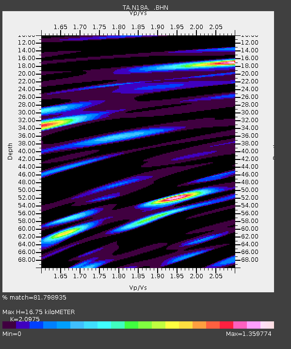
| Estimated Moho Depth: |
16.75 km |
| Estimated Crust Vp/Vs: |
2.10 |
| Assumed Crust Vp: |
6.207 km/s |
| Estimated Crust Vs: |
2.959 km/s |
| Estimated Crust Poisson's Ratio: |
0.35 |
|
| Radial Match: |
81.798935 % |
| Radial Bump: |
400 |
| Transverse Match: |
80.55384 % |
| Transverse Bump: |
400 |
| SOD ConfigId: |
2564 |
| Insert Time: |
2010-03-06 21:52:52.063 +0000 |
| GWidth: |
2.5 |
| Max Bumps: |
400 |
| Tol: |
0.001 |
|

Signal To Noise
| Channel | StoN | STA | LTA |
| TA:N18A: :BHN:20070826T12:49:13.249021Z | 3.462413 | 2.683392E-7 | 7.750063E-8 |
| TA:N18A: :BHE:20070826T12:49:13.249021Z | 5.7650414 | 2.6191742E-7 | 4.5432014E-8 |
| TA:N18A: :BHZ:20070826T12:49:13.249021Z | 18.605783 | 1.0106012E-6 | 5.4316505E-8 |
| Arrivals |
| Ps | 3.0 SECOND |
| PpPs | 8.2 SECOND |
| PsPs/PpSs | 11 SECOND |


