You are here: Home > Network List > TS - TERRAscope (Southern California Seismic Network) Stations List
> Station DGR Domenigoni Valley Reservior, California, USA > Earthquake Result Viewer
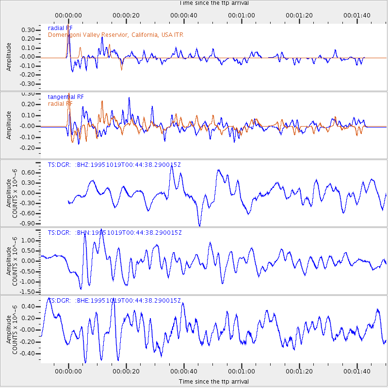
DGR Domenigoni Valley Reservior, California, USA - Earthquake Result Viewer
*The percent match for this event was below the threshold and hence no stack was calculated.
| Earthquake location: |
Ryukyu Islands, Japan |
| Earthquake latitude/longitude: |
28.1/130.2 |
| Earthquake time(UTC): |
1995/10/19 (292) 00:32:06 GMT |
| Earthquake Depth: |
33 km |
| Earthquake Magnitude: |
5.9 MB, 6.3 MS, 6.1 UNKNOWN, 6.4 MW |
| Earthquake Catalog/Contributor: |
WHDF/NEIC |
|
| Network: |
TS TERRAscope (Southern California Seismic Network) |
| Station: |
DGR Domenigoni Valley Reservior, California, USA |
| Lat/Lon: |
33.65 N/117.01 W |
| Elevation: |
700 m |
|
| Distance: |
91.5 deg |
| Az: |
50.293 deg |
| Baz: |
305.468 deg |
| Ray Param: |
$rayparam |
*The percent match for this event was below the threshold and hence was not used in the summary stack. |
|
| Radial Match: |
71.352516 % |
| Radial Bump: |
400 |
| Transverse Match: |
73.4505 % |
| Transverse Bump: |
400 |
| SOD ConfigId: |
4480 |
| Insert Time: |
2010-02-26 14:11:23.715 +0000 |
| GWidth: |
2.5 |
| Max Bumps: |
400 |
| Tol: |
0.001 |
|
Signal To Noise
| Channel | StoN | STA | LTA |
| TS:DGR: :BHN:19951019T00:44:38.290015Z | 3.4414005 | 6.8139195E-7 | 1.9799843E-7 |
| TS:DGR: :BHE:19951019T00:44:38.290015Z | 0.5096214 | 1.2819127E-7 | 2.515422E-7 |
| TS:DGR: :BHZ:19951019T00:44:38.290015Z | 0.5178482 | 9.4730304E-8 | 1.8293065E-7 |
| Arrivals |
| Ps | |
| PpPs | |
| PsPs/PpSs | |


