You are here: Home > Network List > TA - USArray Transportable Network (new EarthScope stations) Stations List
> Station N18A Larsen Ranch, Manila, UT, USA > Earthquake Result Viewer
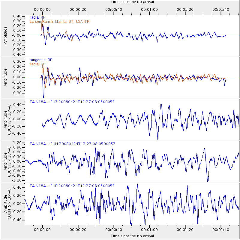
N18A Larsen Ranch, Manila, UT, USA - Earthquake Result Viewer
*The percent match for this event was below the threshold and hence no stack was calculated.
| Earthquake location: |
Central Mid-Atlantic Ridge |
| Earthquake latitude/longitude: |
-1.2/-23.5 |
| Earthquake time(UTC): |
2008/04/24 (115) 12:14:49 GMT |
| Earthquake Depth: |
10 km |
| Earthquake Magnitude: |
6.0 MS, 5.4 MB, 6.5 MW, 6.4 MW |
| Earthquake Catalog/Contributor: |
WHDF/NEIC |
|
| Network: |
TA USArray Transportable Network (new EarthScope stations) |
| Station: |
N18A Larsen Ranch, Manila, UT, USA |
| Lat/Lon: |
40.98 N/109.67 W |
| Elevation: |
1893 m |
|
| Distance: |
87.9 deg |
| Az: |
310.887 deg |
| Baz: |
93.372 deg |
| Ray Param: |
$rayparam |
*The percent match for this event was below the threshold and hence was not used in the summary stack. |
|
| Radial Match: |
63.761234 % |
| Radial Bump: |
400 |
| Transverse Match: |
74.79943 % |
| Transverse Bump: |
400 |
| SOD ConfigId: |
2504 |
| Insert Time: |
2010-03-06 21:53:13.987 +0000 |
| GWidth: |
2.5 |
| Max Bumps: |
400 |
| Tol: |
0.001 |
|
Signal To Noise
| Channel | StoN | STA | LTA |
| TA:N18A: :BHN:20080424T12:27:08.050005Z | 2.0948758 | 2.316947E-7 | 1.1060068E-7 |
| TA:N18A: :BHE:20080424T12:27:08.050005Z | 1.2767465 | 1.0198512E-7 | 7.987891E-8 |
| TA:N18A: :BHZ:20080424T12:27:08.050005Z | 1.4777652 | 1.4124002E-7 | 9.5576766E-8 |
| Arrivals |
| Ps | |
| PpPs | |
| PsPs/PpSs | |


