You are here: Home > Network List > TS - TERRAscope (Southern California Seismic Network) Stations List
> Station DGR Domenigoni Valley Reservior, California, USA > Earthquake Result Viewer
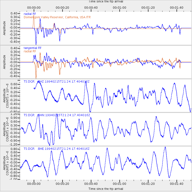
DGR Domenigoni Valley Reservior, California, USA - Earthquake Result Viewer
*The percent match for this event was below the threshold and hence no stack was calculated.
| Earthquake location: |
Loyalty Islands |
| Earthquake latitude/longitude: |
-20.4/168.8 |
| Earthquake time(UTC): |
1994/02/15 (046) 21:11:58 GMT |
| Earthquake Depth: |
33 km |
| Earthquake Magnitude: |
5.6 MB, 6.5 MS, 6.5 UNKNOWN, 6.5 MW |
| Earthquake Catalog/Contributor: |
WHDF/NEIC |
|
| Network: |
TS TERRAscope (Southern California Seismic Network) |
| Station: |
DGR Domenigoni Valley Reservior, California, USA |
| Lat/Lon: |
33.65 N/117.01 W |
| Elevation: |
700 m |
|
| Distance: |
88.7 deg |
| Az: |
53.383 deg |
| Baz: |
244.52 deg |
| Ray Param: |
$rayparam |
*The percent match for this event was below the threshold and hence was not used in the summary stack. |
|
| Radial Match: |
67.71625 % |
| Radial Bump: |
400 |
| Transverse Match: |
62.998573 % |
| Transverse Bump: |
400 |
| SOD ConfigId: |
4480 |
| Insert Time: |
2010-02-26 14:11:24.334 +0000 |
| GWidth: |
2.5 |
| Max Bumps: |
400 |
| Tol: |
0.001 |
|
Signal To Noise
| Channel | StoN | STA | LTA |
| TS:DGR: :BHN:19940215T21:24:17.404016Z | 2.6806755 | 6.8724626E-7 | 2.5637056E-7 |
| TS:DGR: :BHE:19940215T21:24:17.404016Z | 1.7775694 | 3.559327E-7 | 2.002356E-7 |
| TS:DGR: :BHZ:19940215T21:24:17.404016Z | 1.383555 | 4.0665034E-7 | 2.9391697E-7 |
| Arrivals |
| Ps | |
| PpPs | |
| PsPs/PpSs | |


