You are here: Home > Network List > MM - Myanmar National Seismic Network Stations List
> Station TMU Tamu, Sagaing, Myanmar > Earthquake Result Viewer
TMU Tamu, Sagaing, Myanmar - Earthquake Result Viewer
| Earthquake location: |
Carlsberg Ridge |
| Earthquake latitude/longitude: |
10.9/57.2 |
| Earthquake time(UTC): |
2019/04/29 (119) 14:19:52 GMT |
| Earthquake Depth: |
10 km |
| Earthquake Magnitude: |
6.3 Mww |
| Earthquake Catalog/Contributor: |
NEIC PDE/us |
|
| Network: |
MM Myanmar National Seismic Network |
| Station: |
TMU Tamu, Sagaing, Myanmar |
| Lat/Lon: |
24.23 N/94.30 E |
| Elevation: |
182 m |
|
| Distance: |
37.6 deg |
| Az: |
64.333 deg |
| Baz: |
255.887 deg |
| Ray Param: |
0.07602913 |
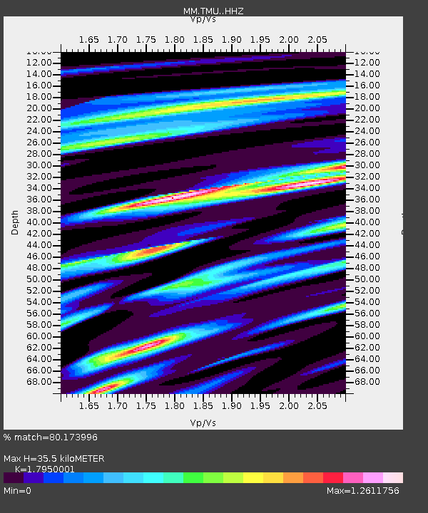
| Estimated Moho Depth: |
35.5 km |
| Estimated Crust Vp/Vs: |
1.80 |
| Assumed Crust Vp: |
6.316 km/s |
| Estimated Crust Vs: |
3.518 km/s |
| Estimated Crust Poisson's Ratio: |
0.27 |
|
| Radial Match: |
80.173996 % |
| Radial Bump: |
400 |
| Transverse Match: |
84.58327 % |
| Transverse Bump: |
400 |
| SOD ConfigId: |
18252611 |
| Insert Time: |
2019-05-13 14:22:17.791 +0000 |
| GWidth: |
2.5 |
| Max Bumps: |
400 |
| Tol: |
0.001 |
|

Signal To Noise
| Channel | StoN | STA | LTA |
| MM:TMU: :HHZ:20190429T14:26:36.627998Z | 35.05947 | 2.4639583E-6 | 7.027939E-8 |
| MM:TMU: :HHN:20190429T14:26:36.627998Z | 7.5466623 | 4.867757E-7 | 6.4502125E-8 |
| MM:TMU: :HHE:20190429T14:26:36.627998Z | 18.409704 | 8.329613E-7 | 4.524577E-8 |
| Arrivals |
| Ps | 4.8 SECOND |
| PpPs | 15 SECOND |
| PsPs/PpSs | 19 SECOND |


