You are here: Home > Network List > IW - Intermountain West Stations List
> Station MOOW Moose Ponds, Wyoming, USA > Earthquake Result Viewer
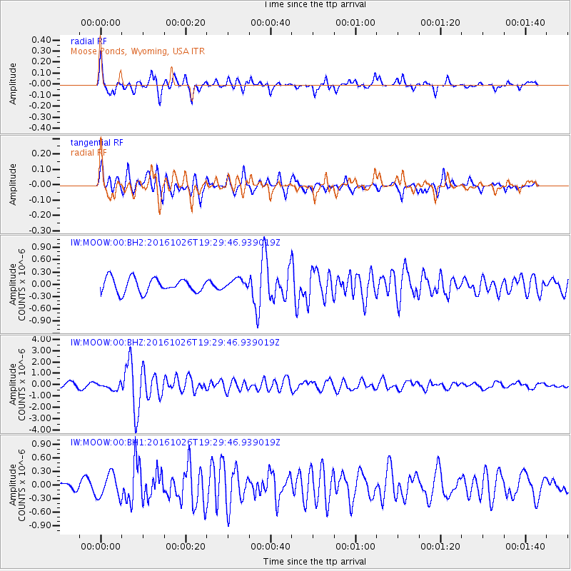
MOOW Moose Ponds, Wyoming, USA - Earthquake Result Viewer
*The percent match for this event was below the threshold and hence no stack was calculated.
| Earthquake location: |
Central Italy |
| Earthquake latitude/longitude: |
42.9/13.0 |
| Earthquake time(UTC): |
2016/10/26 (300) 19:18:08 GMT |
| Earthquake Depth: |
10 km |
| Earthquake Magnitude: |
6.1 MWW, 6.0 MWB, 6.1 MWR |
| Earthquake Catalog/Contributor: |
NEIC PDE/NEIC COMCAT |
|
| Network: |
IW Intermountain West |
| Station: |
MOOW Moose Ponds, Wyoming, USA |
| Lat/Lon: |
43.75 N/110.74 W |
| Elevation: |
2128 m |
|
| Distance: |
80.1 deg |
| Az: |
322.311 deg |
| Baz: |
38.285 deg |
| Ray Param: |
$rayparam |
*The percent match for this event was below the threshold and hence was not used in the summary stack. |
|
| Radial Match: |
81.14339 % |
| Radial Bump: |
400 |
| Transverse Match: |
81.51319 % |
| Transverse Bump: |
400 |
| SOD ConfigId: |
1815711 |
| Insert Time: |
2016-11-09 19:23:22.297 +0000 |
| GWidth: |
2.5 |
| Max Bumps: |
400 |
| Tol: |
0.001 |
|
Signal To Noise
| Channel | StoN | STA | LTA |
| IW:MOOW:00:BHZ:20161026T19:29:46.939019Z | 1.473007 | 3.0203844E-7 | 2.050489E-7 |
| IW:MOOW:00:BH1:20161026T19:29:46.939019Z | 2.5371847 | 2.638399E-7 | 1.0398923E-7 |
| IW:MOOW:00:BH2:20161026T19:29:46.939019Z | 0.7138737 | 1.2373314E-7 | 1.733264E-7 |
| Arrivals |
| Ps | |
| PpPs | |
| PsPs/PpSs | |


