You are here: Home > Network List > TA - USArray Transportable Network (new EarthScope stations) Stations List
> Station G16K Koyuk River, AK, USA > Earthquake Result Viewer
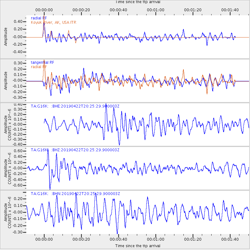
G16K Koyuk River, AK, USA - Earthquake Result Viewer
*The percent match for this event was below the threshold and hence no stack was calculated.
| Earthquake location: |
Near Coast Of Guerrero, Mexico |
| Earthquake latitude/longitude: |
16.4/-98.5 |
| Earthquake time(UTC): |
2019/04/22 (112) 20:15:24 GMT |
| Earthquake Depth: |
12 km |
| Earthquake Magnitude: |
5.4 Mww |
| Earthquake Catalog/Contributor: |
NEIC PDE/us |
|
| Network: |
TA USArray Transportable Network (new EarthScope stations) |
| Station: |
G16K Koyuk River, AK, USA |
| Lat/Lon: |
65.39 N/162.35 W |
| Elevation: |
169 m |
|
| Distance: |
64.5 deg |
| Az: |
335.378 deg |
| Baz: |
107.198 deg |
| Ray Param: |
$rayparam |
*The percent match for this event was below the threshold and hence was not used in the summary stack. |
|
| Radial Match: |
71.1852 % |
| Radial Bump: |
400 |
| Transverse Match: |
72.42469 % |
| Transverse Bump: |
353 |
| SOD ConfigId: |
18252611 |
| Insert Time: |
2019-05-16 14:00:39.931 +0000 |
| GWidth: |
2.5 |
| Max Bumps: |
400 |
| Tol: |
0.001 |
|
Signal To Noise
| Channel | StoN | STA | LTA |
| TA:G16K: :BHZ:20190422T20:25:29.900003Z | 6.0059376 | 3.3938733E-7 | 5.6508636E-8 |
| TA:G16K: :BHN:20190422T20:25:29.900003Z | 1.0054117 | 9.324024E-8 | 9.273837E-8 |
| TA:G16K: :BHE:20190422T20:25:29.900003Z | 2.1980643 | 1.7556765E-7 | 7.987375E-8 |
| Arrivals |
| Ps | |
| PpPs | |
| PsPs/PpSs | |


