You are here: Home > Network List > US - United States National Seismic Network Stations List
> Station MSO Missoula, Montana, USA > Earthquake Result Viewer
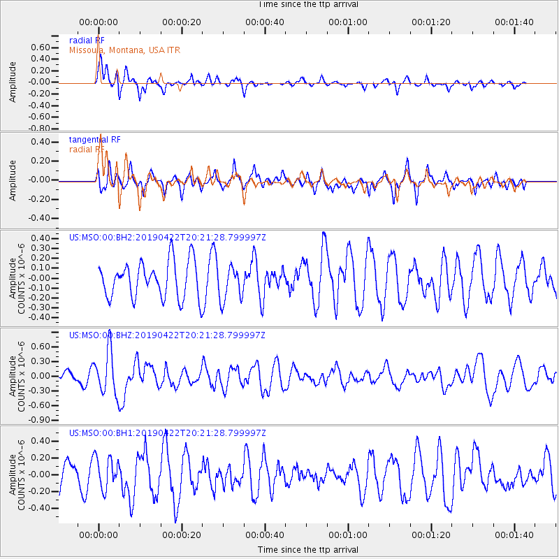
MSO Missoula, Montana, USA - Earthquake Result Viewer
*The percent match for this event was below the threshold and hence no stack was calculated.
| Earthquake location: |
Near Coast Of Guerrero, Mexico |
| Earthquake latitude/longitude: |
16.4/-98.5 |
| Earthquake time(UTC): |
2019/04/22 (112) 20:15:24 GMT |
| Earthquake Depth: |
12 km |
| Earthquake Magnitude: |
5.4 Mww |
| Earthquake Catalog/Contributor: |
NEIC PDE/us |
|
| Network: |
US United States National Seismic Network |
| Station: |
MSO Missoula, Montana, USA |
| Lat/Lon: |
46.83 N/113.94 W |
| Elevation: |
1264 m |
|
| Distance: |
33.0 deg |
| Az: |
340.36 deg |
| Baz: |
151.969 deg |
| Ray Param: |
$rayparam |
*The percent match for this event was below the threshold and hence was not used in the summary stack. |
|
| Radial Match: |
66.423485 % |
| Radial Bump: |
400 |
| Transverse Match: |
51.69922 % |
| Transverse Bump: |
400 |
| SOD ConfigId: |
18252611 |
| Insert Time: |
2019-05-16 14:01:48.894 +0000 |
| GWidth: |
2.5 |
| Max Bumps: |
400 |
| Tol: |
0.001 |
|
Signal To Noise
| Channel | StoN | STA | LTA |
| US:MSO:00:BHZ:20190422T20:21:28.799997Z | 4.0395393 | 4.6027483E-7 | 1.1394241E-7 |
| US:MSO:00:BH1:20190422T20:21:28.799997Z | 1.074971 | 1.8570138E-7 | 1.7275013E-7 |
| US:MSO:00:BH2:20190422T20:21:28.799997Z | 0.94592226 | 1.7395213E-7 | 1.8389686E-7 |
| Arrivals |
| Ps | |
| PpPs | |
| PsPs/PpSs | |


