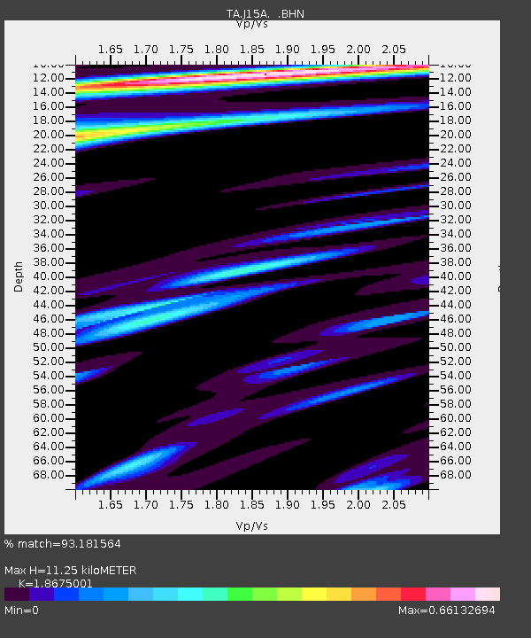
J15A Blackfoot, ID, USA - Earthquake Result Viewer
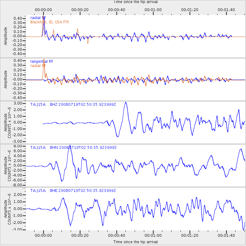
Earthquake location: Off East Coast Of Honshu, Japan
Earthquake latitude/longitude: 37.6/142.2
Earthquake time(UTC): 2008/07/19 (201) 02:39:28 GMT
Earthquake Depth: 22 km
Earthquake Magnitude: 6.2 MB, 7.0 MS, 7.0 MW, 6.9 MW
Earthquake Catalog/Contributor: WHDF/NEIC
Network: TA USArray Transportable Network (new EarthScope stations)
Station: J15A Blackfoot, ID, USA
Lat/Lon: 43.40 N/112.43 W
Elevation: 1497 m
Distance: 74.8 deg
Az: 46.747 deg
Baz: 307.422 deg
Ray Param: 0.05206469
Estimated Moho Depth: 11.25 km
Estimated Crust Vp/Vs: 1.87
Assumed Crust Vp: 6.279 km/s
Estimated Crust Vs: 3.362 km/s
Estimated Crust Poisson's Ratio: 0.30
Radial Match: 93.181564 %
Radial Bump: 400
Transverse Match: 73.88452 %
Transverse Bump: 400
SOD ConfigId: 2504
Insert Time: 2010-03-06 21:55:13.098 +0000
GWidth: 2.5
Max Bumps: 400
Tol: 0.001

Signal To Noise

ChannelStoNSTALTA
TA:J15A: :BHN:20080719T02:50:35.923999Z5.7766425.2132737E-79.024748E-8
TA:J15A: :BHE:20080719T02:50:35.923999Z0.995708358.065796E-88.100561E-8
TA:J15A: :BHZ:20080719T02:50:35.923999Z1.7861941.3998728E-77.8371826E-8
Arrivals
Ps1.6 SECOND
PpPs5.0 SECOND
PsPs/PpSs6.6 SECOND