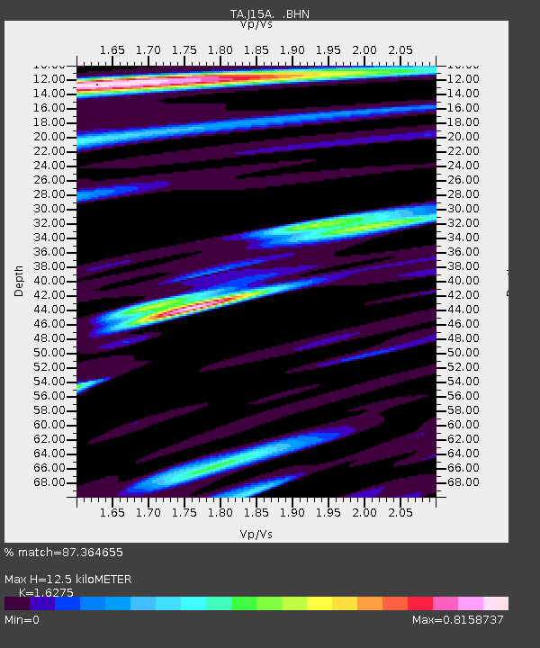
J15A Blackfoot, ID, USA - Earthquake Result Viewer
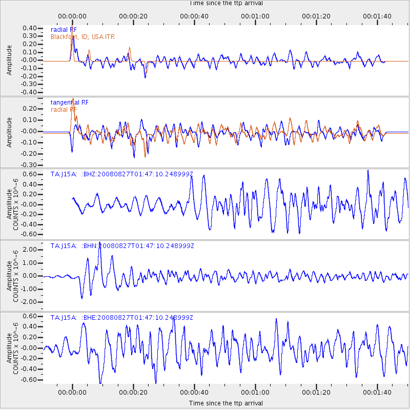
Earthquake location: Lake Baykal Region, Russia
Earthquake latitude/longitude: 51.6/104.2
Earthquake time(UTC): 2008/08/27 (240) 01:35:32 GMT
Earthquake Depth: 16 km
Earthquake Magnitude: 5.8 MB, 6.2 MS, 6.2 MW, 6.2 MW
Earthquake Catalog/Contributor: WHDF/NEIC
Network: TA USArray Transportable Network (new EarthScope stations)
Station: J15A Blackfoot, ID, USA
Lat/Lon: 43.40 N/112.43 W
Elevation: 1497 m
Distance: 80.2 deg
Az: 26.163 deg
Baz: 337.837 deg
Ray Param: 0.04843026
Estimated Moho Depth: 12.5 km
Estimated Crust Vp/Vs: 1.63
Assumed Crust Vp: 6.279 km/s
Estimated Crust Vs: 3.858 km/s
Estimated Crust Poisson's Ratio: 0.20
Radial Match: 87.364655 %
Radial Bump: 400
Transverse Match: 85.31804 %
Transverse Bump: 400
SOD ConfigId: 2504
Insert Time: 2010-03-06 21:55:21.613 +0000
GWidth: 2.5
Max Bumps: 400
Tol: 0.001

Signal To Noise

ChannelStoNSTALTA
TA:J15A: :BHN:20080827T01:47:10.248999Z7.7896896.6337446E-78.5160586E-8
TA:J15A: :BHE:20080827T01:47:10.248999Z2.74980142.3503708E-78.54742E-8
TA:J15A: :BHZ:20080827T01:47:10.248999Z0.91347459.1892254E-81.0059641E-7
Arrivals
Ps1.3 SECOND
PpPs5.1 SECOND
PsPs/PpSs6.4 SECOND