You are here: Home > Network List > TA - USArray Transportable Network (new EarthScope stations) Stations List
> Station J15A Blackfoot, ID, USA > Earthquake Result Viewer
J15A Blackfoot, ID, USA - Earthquake Result Viewer
| Earthquake location: |
Vanuatu Islands |
| Earthquake latitude/longitude: |
-14.8/168.0 |
| Earthquake time(UTC): |
2008/11/07 (312) 07:19:35 GMT |
| Earthquake Depth: |
13 km |
| Earthquake Magnitude: |
6.0 MB, 6.3 MS, 6.4 MW, 6.4 MW |
| Earthquake Catalog/Contributor: |
WHDF/NEIC |
|
| Network: |
TA USArray Transportable Network (new EarthScope stations) |
| Station: |
J15A Blackfoot, ID, USA |
| Lat/Lon: |
43.40 N/112.43 W |
| Elevation: |
1497 m |
|
| Distance: |
92.6 deg |
| Az: |
45.85 deg |
| Baz: |
252.183 deg |
| Ray Param: |
0.041416906 |
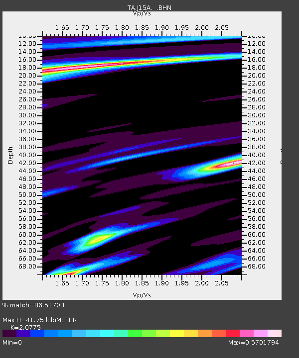
| Estimated Moho Depth: |
41.75 km |
| Estimated Crust Vp/Vs: |
2.08 |
| Assumed Crust Vp: |
6.279 km/s |
| Estimated Crust Vs: |
3.022 km/s |
| Estimated Crust Poisson's Ratio: |
0.35 |
|
| Radial Match: |
86.51703 % |
| Radial Bump: |
347 |
| Transverse Match: |
69.4495 % |
| Transverse Bump: |
400 |
| SOD ConfigId: |
2658 |
| Insert Time: |
2010-03-06 21:55:23.844 +0000 |
| GWidth: |
2.5 |
| Max Bumps: |
400 |
| Tol: |
0.001 |
|

Signal To Noise
| Channel | StoN | STA | LTA |
| TA:J15A: :BHN:20081107T07:32:15.425027Z | 4.61889 | 4.0272883E-7 | 8.7191694E-8 |
| TA:J15A: :BHE:20081107T07:32:15.425027Z | 0.78559893 | 1.3220215E-7 | 1.6828199E-7 |
| TA:J15A: :BHZ:20081107T07:32:15.425027Z | 1.0051708 | 1.14176316E-7 | 1.1358897E-7 |
| Arrivals |
| Ps | 7.3 SECOND |
| PpPs | 20 SECOND |
| PsPs/PpSs | 27 SECOND |


