You are here: Home > Network List > TA - USArray Transportable Network (new EarthScope stations) Stations List
> Station J15A Blackfoot, ID, USA > Earthquake Result Viewer
J15A Blackfoot, ID, USA - Earthquake Result Viewer
| Earthquake location: |
Kermadec Islands Region |
| Earthquake latitude/longitude: |
-27.4/-176.3 |
| Earthquake time(UTC): |
2009/02/18 (049) 21:53:45 GMT |
| Earthquake Depth: |
25 km |
| Earthquake Magnitude: |
6.8 MB, 7.2 MS, 6.9 MW, 6.9 MW |
| Earthquake Catalog/Contributor: |
WHDF/NEIC |
|
| Network: |
TA USArray Transportable Network (new EarthScope stations) |
| Station: |
J15A Blackfoot, ID, USA |
| Lat/Lon: |
43.40 N/112.43 W |
| Elevation: |
1497 m |
|
| Distance: |
91.6 deg |
| Az: |
40.904 deg |
| Baz: |
232.991 deg |
| Ray Param: |
0.041573998 |
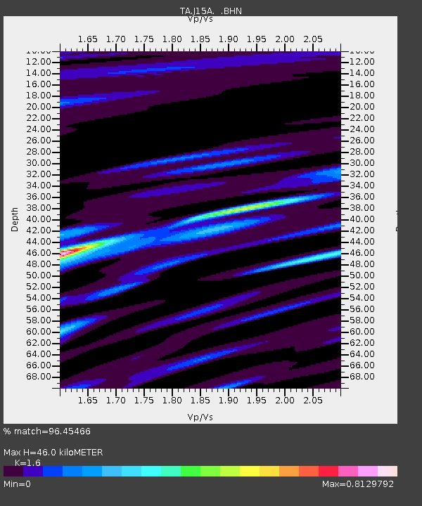
| Estimated Moho Depth: |
46.0 km |
| Estimated Crust Vp/Vs: |
1.60 |
| Assumed Crust Vp: |
6.279 km/s |
| Estimated Crust Vs: |
3.924 km/s |
| Estimated Crust Poisson's Ratio: |
0.18 |
|
| Radial Match: |
96.45466 % |
| Radial Bump: |
305 |
| Transverse Match: |
89.58073 % |
| Transverse Bump: |
355 |
| SOD ConfigId: |
2658 |
| Insert Time: |
2010-03-06 21:55:38.259 +0000 |
| GWidth: |
2.5 |
| Max Bumps: |
400 |
| Tol: |
0.001 |
|

Signal To Noise
| Channel | StoN | STA | LTA |
| TA:J15A: :BHN:20090218T22:06:18.524014Z | 6.299142 | 1.6291456E-6 | 2.5862977E-7 |
| TA:J15A: :BHE:20090218T22:06:18.524014Z | 1.4048824 | 4.82382E-7 | 3.433611E-7 |
| TA:J15A: :BHZ:20090218T22:06:18.524014Z | 1.2134235 | 4.4527772E-7 | 3.6695988E-7 |
| Arrivals |
| Ps | 4.5 SECOND |
| PpPs | 19 SECOND |
| PsPs/PpSs | 23 SECOND |


