You are here: Home > Network List > TA - USArray Transportable Network (new EarthScope stations) Stations List
> Station J15A Blackfoot, ID, USA > Earthquake Result Viewer
J15A Blackfoot, ID, USA - Earthquake Result Viewer
| Earthquake location: |
Guatemala |
| Earthquake latitude/longitude: |
14.6/-91.2 |
| Earthquake time(UTC): |
2009/05/03 (123) 16:21:47 GMT |
| Earthquake Depth: |
124 km |
| Earthquake Magnitude: |
5.6 MB, 6.2 MW, 6.2 MW |
| Earthquake Catalog/Contributor: |
WHDF/NEIC |
|
| Network: |
TA USArray Transportable Network (new EarthScope stations) |
| Station: |
J15A Blackfoot, ID, USA |
| Lat/Lon: |
43.40 N/112.43 W |
| Elevation: |
1497 m |
|
| Distance: |
34.0 deg |
| Az: |
331.804 deg |
| Baz: |
141.123 deg |
| Ray Param: |
0.07755241 |
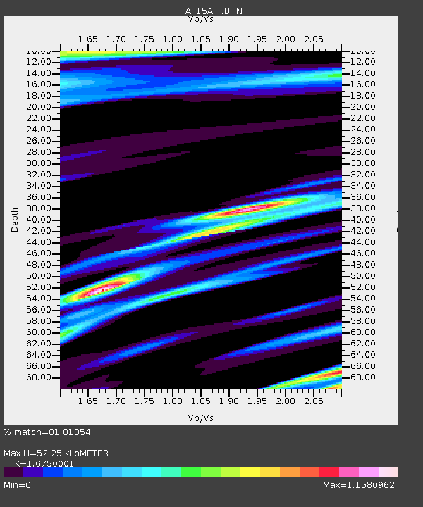
| Estimated Moho Depth: |
52.25 km |
| Estimated Crust Vp/Vs: |
1.68 |
| Assumed Crust Vp: |
6.279 km/s |
| Estimated Crust Vs: |
3.748 km/s |
| Estimated Crust Poisson's Ratio: |
0.22 |
|
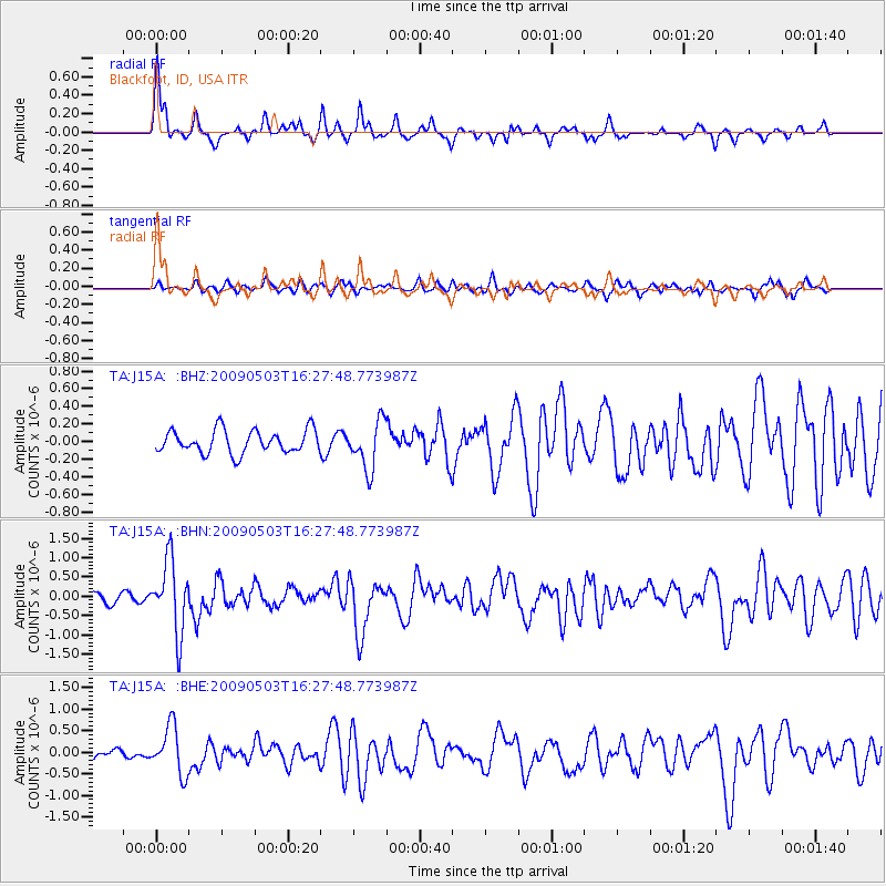
| Radial Match: |
81.81854 % |
| Radial Bump: |
300 |
| Transverse Match: |
64.71378 % |
| Transverse Bump: |
400 |
| SOD ConfigId: |
2658 |
| Insert Time: |
2010-03-06 21:55:52.512 +0000 |
| GWidth: |
2.5 |
| Max Bumps: |
400 |
| Tol: |
0.001 |
|
Signal To Noise
| Channel | StoN | STA | LTA |
| TA:J15A: :BHN:20090503T16:27:48.773987Z | 8.074442 | 9.268416E-7 | 1.14787085E-7 |
| TA:J15A: :BHE:20090503T16:27:48.773987Z | 3.343922 | 5.5112497E-7 | 1.6481395E-7 |
| TA:J15A: :BHZ:20090503T16:27:48.773987Z | 2.105659 | 2.7575308E-7 | 1.3095809E-7 |
| Arrivals |
| Ps | 6.1 SECOND |
| PpPs | 21 SECOND |
| PsPs/PpSs | 27 SECOND |


