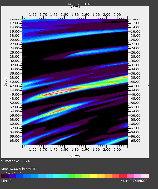
J15A Blackfoot, ID, USA - Earthquake Result Viewer
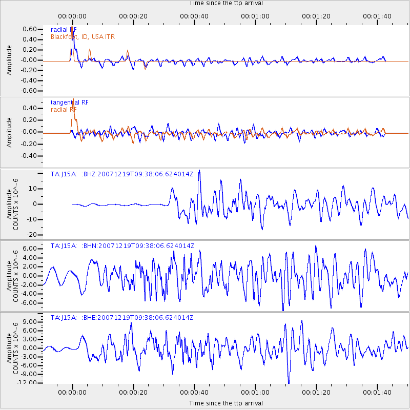
Earthquake location: Andreanof Islands, Aleutian Is.
Earthquake latitude/longitude: 51.4/-179.5
Earthquake time(UTC): 2007/12/19 (353) 09:30:27 GMT
Earthquake Depth: 29 km
Earthquake Magnitude: 6.4 MB, 7.1 MS, 7.1 MW, 7.0 MW
Earthquake Catalog/Contributor: WHDF/NEIC
Network: TA USArray Transportable Network (new EarthScope stations)
Station: J15A Blackfoot, ID, USA
Lat/Lon: 43.40 N/112.43 W
Elevation: 1497 m
Distance: 44.7 deg
Az: 72.773 deg
Baz: 304.759 deg
Ray Param: 0.07172642
Estimated Moho Depth: 44.5 km
Estimated Crust Vp/Vs: 1.77
Assumed Crust Vp: 6.279 km/s
Estimated Crust Vs: 3.542 km/s
Estimated Crust Poisson's Ratio: 0.27
Radial Match: 92.324 %
Radial Bump: 400
Transverse Match: 79.70088 %
Transverse Bump: 400
SOD ConfigId: 2564
Insert Time: 2010-03-06 21:56:00.362 +0000
GWidth: 2.5
Max Bumps: 400
Tol: 0.001

Signal To Noise

ChannelStoNSTALTA
TA:J15A: :BHN:20071219T09:38:06.624014Z2.28268862.217148E-69.712879E-7
TA:J15A: :BHE:20071219T09:38:06.624014Z2.32544232.1730582E-69.344709E-7
TA:J15A: :BHZ:20071219T09:38:06.624014Z10.4354984.7954013E-64.5952777E-7
Arrivals
Ps5.8 SECOND
PpPs18 SECOND
PsPs/PpSs24 SECOND