You are here: Home > Network List > TA - USArray Transportable Network (new EarthScope stations) Stations List
> Station J15A Blackfoot, ID, USA > Earthquake Result Viewer
J15A Blackfoot, ID, USA - Earthquake Result Viewer
| Earthquake location: |
South Of Fiji Islands |
| Earthquake latitude/longitude: |
-26.0/-177.5 |
| Earthquake time(UTC): |
2007/12/09 (343) 07:28:20 GMT |
| Earthquake Depth: |
152 km |
| Earthquake Magnitude: |
7.0 MB, 7.8 MW, 7.7 MW |
| Earthquake Catalog/Contributor: |
WHDF/NEIC |
|
| Network: |
TA USArray Transportable Network (new EarthScope stations) |
| Station: |
J15A Blackfoot, ID, USA |
| Lat/Lon: |
43.40 N/112.43 W |
| Elevation: |
1497 m |
|
| Distance: |
91.3 deg |
| Az: |
41.39 deg |
| Baz: |
234.725 deg |
| Ray Param: |
0.04156806 |
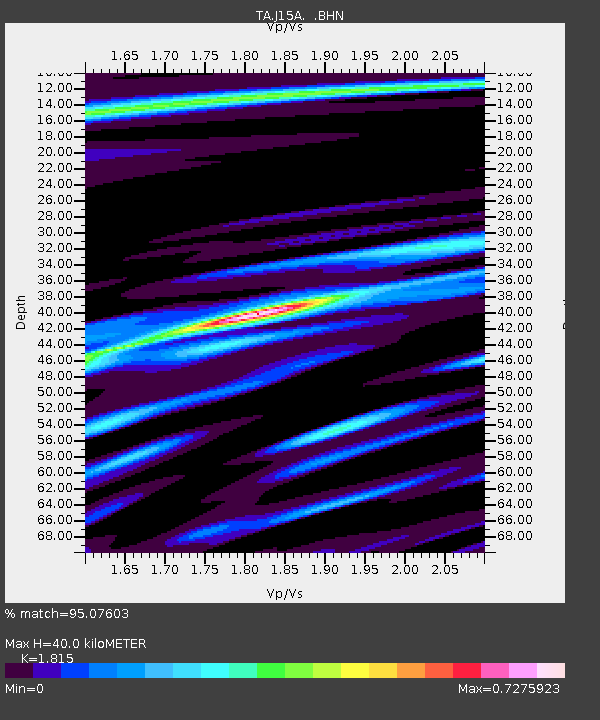
| Estimated Moho Depth: |
40.0 km |
| Estimated Crust Vp/Vs: |
1.82 |
| Assumed Crust Vp: |
6.279 km/s |
| Estimated Crust Vs: |
3.459 km/s |
| Estimated Crust Poisson's Ratio: |
0.28 |
|
| Radial Match: |
95.07603 % |
| Radial Bump: |
353 |
| Transverse Match: |
86.77509 % |
| Transverse Bump: |
400 |
| SOD ConfigId: |
2564 |
| Insert Time: |
2010-03-06 21:56:04.046 +0000 |
| GWidth: |
2.5 |
| Max Bumps: |
400 |
| Tol: |
0.001 |
|

Signal To Noise
| Channel | StoN | STA | LTA |
| TA:J15A: :BHN:20071209T07:40:37.600029Z | 1.7441027 | 2.857165E-7 | 1.6381863E-7 |
| TA:J15A: :BHE:20071209T07:40:37.600029Z | 1.7159342 | 3.7955562E-7 | 2.2119474E-7 |
| TA:J15A: :BHZ:20071209T07:40:37.600029Z | 5.1749578 | 1.0343452E-6 | 1.998751E-7 |
| Arrivals |
| Ps | 5.3 SECOND |
| PpPs | 18 SECOND |
| PsPs/PpSs | 23 SECOND |


