You are here: Home > Network List > TA - USArray Transportable Network (new EarthScope stations) Stations List
> Station J15A Blackfoot, ID, USA > Earthquake Result Viewer
J15A Blackfoot, ID, USA - Earthquake Result Viewer
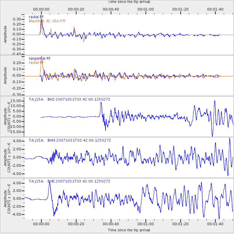
| Earthquake location: |
Mariana Islands |
| Earthquake latitude/longitude: |
18.9/145.4 |
| Earthquake time(UTC): |
2007/10/31 (304) 03:30:17 GMT |
| Earthquake Depth: |
223 km |
| Earthquake Magnitude: |
6.2 MB, 7.2 MW, 7.2 MW |
| Earthquake Catalog/Contributor: |
WHDF/NEIC |
|
| Network: |
TA USArray Transportable Network (new EarthScope stations) |
| Station: |
J15A Blackfoot, ID, USA |
| Lat/Lon: |
43.40 N/112.43 W |
| Elevation: |
1497 m |
|
| Distance: |
85.7 deg |
| Az: |
45.593 deg |
| Baz: |
291.882 deg |
| Ray Param: |
0.044030033 |
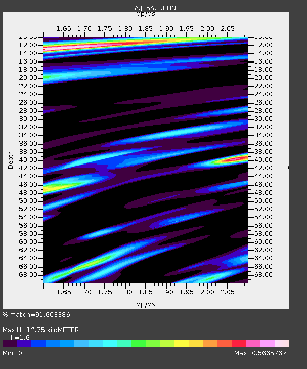
| Estimated Moho Depth: |
12.75 km |
| Estimated Crust Vp/Vs: |
1.60 |
| Assumed Crust Vp: |
6.279 km/s |
| Estimated Crust Vs: |
3.924 km/s |
| Estimated Crust Poisson's Ratio: |
0.18 |
|
| Radial Match: |
91.603386 % |
| Radial Bump: |
400 |
| Transverse Match: |
74.513016 % |
| Transverse Bump: |
400 |
| SOD ConfigId: |
2564 |
| Insert Time: |
2010-03-06 21:56:09.624 +0000 |
| GWidth: |
2.5 |
| Max Bumps: |
400 |
| Tol: |
0.001 |
|
Signal To Noise
| Channel | StoN | STA | LTA |
| TA:J15A: :BHN:20071031T03:42:00.125027Z | 2.4205332 | 4.5794297E-7 | 1.8919096E-7 |
| TA:J15A: :BHE:20071031T03:42:00.125027Z | 3.7023215 | 1.3177336E-6 | 3.559209E-7 |
| TA:J15A: :BHZ:20071031T03:42:00.125027Z | 18.415573 | 4.7958765E-6 | 2.6042505E-7 |
| Arrivals |
| Ps | 1.2 SECOND |
| PpPs | 5.2 SECOND |
| PsPs/PpSs | 6.4 SECOND |


