You are here: Home > Network List > US - United States National Seismic Network Stations List
> Station HAWA Hanford, Washington, USA > Earthquake Result Viewer
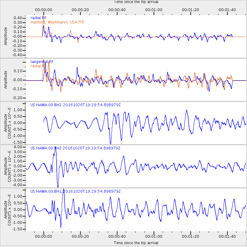
HAWA Hanford, Washington, USA - Earthquake Result Viewer
*The percent match for this event was below the threshold and hence no stack was calculated.
| Earthquake location: |
Central Italy |
| Earthquake latitude/longitude: |
42.9/13.0 |
| Earthquake time(UTC): |
2016/10/26 (300) 19:18:08 GMT |
| Earthquake Depth: |
10 km |
| Earthquake Magnitude: |
6.1 MWW, 6.0 MWB, 6.1 MWR |
| Earthquake Catalog/Contributor: |
NEIC PDE/NEIC COMCAT |
|
| Network: |
US United States National Seismic Network |
| Station: |
HAWA Hanford, Washington, USA |
| Lat/Lon: |
46.39 N/119.53 W |
| Elevation: |
364 m |
|
| Distance: |
81.6 deg |
| Az: |
328.99 deg |
| Baz: |
33.138 deg |
| Ray Param: |
$rayparam |
*The percent match for this event was below the threshold and hence was not used in the summary stack. |
|
| Radial Match: |
60.803196 % |
| Radial Bump: |
391 |
| Transverse Match: |
69.816734 % |
| Transverse Bump: |
400 |
| SOD ConfigId: |
1815711 |
| Insert Time: |
2016-11-09 19:25:05.539 +0000 |
| GWidth: |
2.5 |
| Max Bumps: |
400 |
| Tol: |
0.001 |
|
Signal To Noise
| Channel | StoN | STA | LTA |
| US:HAWA:00:BHZ:20161026T19:29:54.898979Z | 1.261803 | 7.7415535E-7 | 6.1353103E-7 |
| US:HAWA:00:BH1:20161026T19:29:54.898979Z | 0.6390248 | 2.2001463E-7 | 3.4429746E-7 |
| US:HAWA:00:BH2:20161026T19:29:54.898979Z | 1.8077476 | 5.13517E-7 | 2.8406455E-7 |
| Arrivals |
| Ps | |
| PpPs | |
| PsPs/PpSs | |


