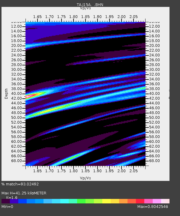
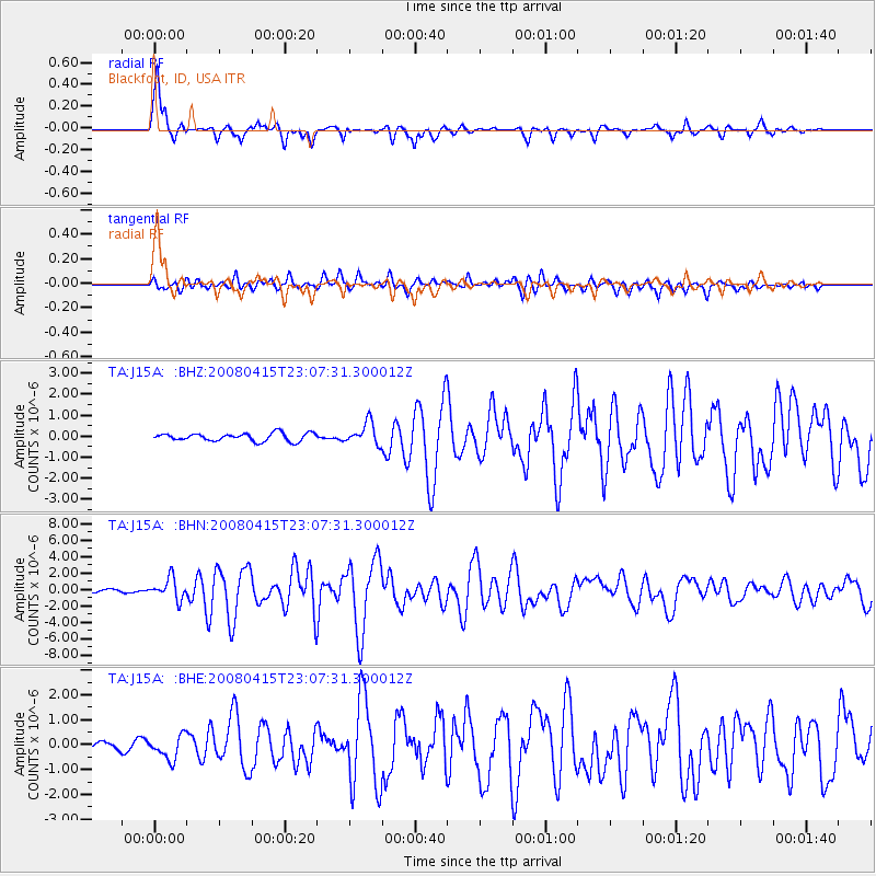
J15A Blackfoot, ID, USA - Earthquake Result Viewer

Earthquake location: Andreanof Islands, Aleutian Is.
Earthquake latitude/longitude: 51.9/-179.4
Earthquake time(UTC): 2008/04/15 (106) 22:59:51 GMT
Earthquake Depth: 10 km
Earthquake Magnitude: 6.1 MB, 6.4 MS, 6.4 MW, 6.4 MW
Earthquake Catalog/Contributor: WHDF/NEIC
Network: TA USArray Transportable Network (new EarthScope stations)
Station: J15A Blackfoot, ID, USA
Lat/Lon: 43.40 N/112.43 W
Elevation: 1497 m
Distance: 44.4 deg
Az: 73.349 deg
Baz: 305.387 deg
Ray Param: 0.07192794
Estimated Moho Depth: 41.25 km
Estimated Crust Vp/Vs: 1.60
Assumed Crust Vp: 6.279 km/s
Estimated Crust Vs: 3.924 km/s
Estimated Crust Poisson's Ratio: 0.18
Radial Match: 93.02492 %
Radial Bump: 291
Transverse Match: 75.043655 %
Transverse Bump: 400
SOD ConfigId: 2504
Insert Time: 2010-03-06 21:56:26.921 +0000
GWidth: 2.5
Max Bumps: 400
Tol: 0.001

Signal To Noise

ChannelStoNSTALTA
TA:J15A: :BHN:20080415T23:07:31.300012Z10.5499791.2752789E-61.2087975E-7
TA:J15A: :BHE:20080415T23:07:31.300012Z3.4953564.6887249E-71.3414154E-7
TA:J15A: :BHZ:20080415T23:07:31.300012Z2.76507525.2198067E-71.887763E-7
Arrivals
Ps4.2 SECOND
PpPs16 SECOND
PsPs/PpSs20 SECOND