You are here: Home > Network List > TA - USArray Transportable Network (new EarthScope stations) Stations List
> Station J15A Blackfoot, ID, USA > Earthquake Result Viewer
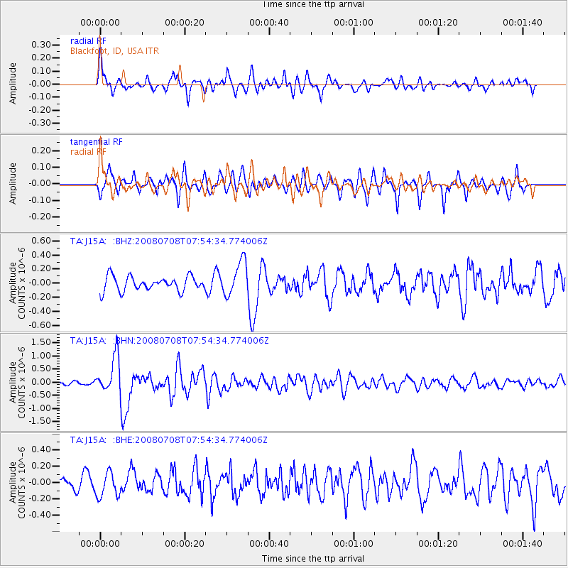
J15A Blackfoot, ID, USA - Earthquake Result Viewer
*The percent match for this event was below the threshold and hence no stack was calculated.
| Earthquake location: |
Ryukyu Islands, Japan |
| Earthquake latitude/longitude: |
27.5/128.3 |
| Earthquake time(UTC): |
2008/07/08 (190) 07:42:10 GMT |
| Earthquake Depth: |
43 km |
| Earthquake Magnitude: |
6.0 MB, 5.5 MS, 6.0 MW, 6.0 MW |
| Earthquake Catalog/Contributor: |
WHDF/NEIC |
|
| Network: |
TA USArray Transportable Network (new EarthScope stations) |
| Station: |
J15A Blackfoot, ID, USA |
| Lat/Lon: |
43.40 N/112.43 W |
| Elevation: |
1497 m |
|
| Distance: |
90.1 deg |
| Az: |
39.498 deg |
| Baz: |
309.202 deg |
| Ray Param: |
$rayparam |
*The percent match for this event was below the threshold and hence was not used in the summary stack. |
|
| Radial Match: |
77.36748 % |
| Radial Bump: |
400 |
| Transverse Match: |
65.51523 % |
| Transverse Bump: |
397 |
| SOD ConfigId: |
2504 |
| Insert Time: |
2010-03-06 21:57:01.868 +0000 |
| GWidth: |
2.5 |
| Max Bumps: |
400 |
| Tol: |
0.001 |
|
Signal To Noise
| Channel | StoN | STA | LTA |
| TA:J15A: :BHN:20080708T07:54:34.774006Z | 10.22877 | 7.239618E-7 | 7.077701E-8 |
| TA:J15A: :BHE:20080708T07:54:34.774006Z | 1.7131331 | 1.5174568E-7 | 8.857787E-8 |
| TA:J15A: :BHZ:20080708T07:54:34.774006Z | 2.4678235 | 2.5212626E-7 | 1.0216542E-7 |
| Arrivals |
| Ps | |
| PpPs | |
| PsPs/PpSs | |


