You are here: Home > Network List > TA - USArray Transportable Network (new EarthScope stations) Stations List
> Station J15A Blackfoot, ID, USA > Earthquake Result Viewer
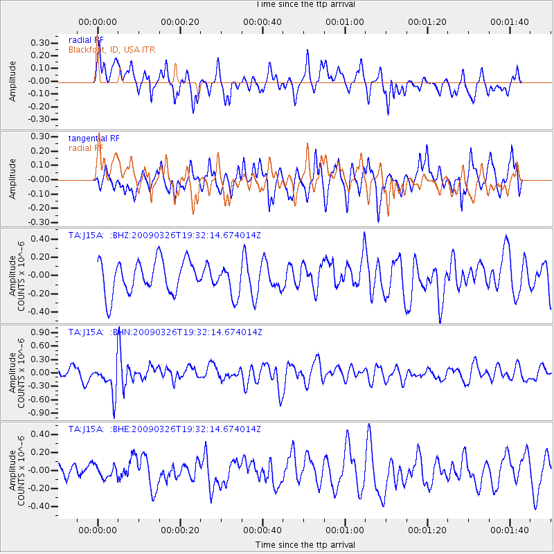
J15A Blackfoot, ID, USA - Earthquake Result Viewer
*The percent match for this event was below the threshold and hence no stack was calculated.
| Earthquake location: |
Northwest Of Ryukyu Islands |
| Earthquake latitude/longitude: |
27.4/126.7 |
| Earthquake time(UTC): |
2009/03/26 (085) 19:19:59 GMT |
| Earthquake Depth: |
160 km |
| Earthquake Magnitude: |
5.6 MB, 5.9 MW, 5.9 MW |
| Earthquake Catalog/Contributor: |
WHDF/NEIC |
|
| Network: |
TA USArray Transportable Network (new EarthScope stations) |
| Station: |
J15A Blackfoot, ID, USA |
| Lat/Lon: |
43.40 N/112.43 W |
| Elevation: |
1497 m |
|
| Distance: |
91.1 deg |
| Az: |
38.738 deg |
| Baz: |
310.253 deg |
| Ray Param: |
$rayparam |
*The percent match for this event was below the threshold and hence was not used in the summary stack. |
|
| Radial Match: |
62.9785 % |
| Radial Bump: |
400 |
| Transverse Match: |
55.7399 % |
| Transverse Bump: |
362 |
| SOD ConfigId: |
2658 |
| Insert Time: |
2010-03-06 21:57:34.550 +0000 |
| GWidth: |
2.5 |
| Max Bumps: |
400 |
| Tol: |
0.001 |
|
Signal To Noise
| Channel | StoN | STA | LTA |
| TA:J15A: :BHN:20090326T19:32:14.674014Z | 2.858564 | 3.6476882E-7 | 1.2760562E-7 |
| TA:J15A: :BHE:20090326T19:32:14.674014Z | 0.51200753 | 6.676205E-8 | 1.303927E-7 |
| TA:J15A: :BHZ:20090326T19:32:14.674014Z | 0.96858317 | 1.7373961E-7 | 1.79375E-7 |
| Arrivals |
| Ps | |
| PpPs | |
| PsPs/PpSs | |


