You are here: Home > Network List > TA - USArray Transportable Network (new EarthScope stations) Stations List
> Station J15A Blackfoot, ID, USA > Earthquake Result Viewer
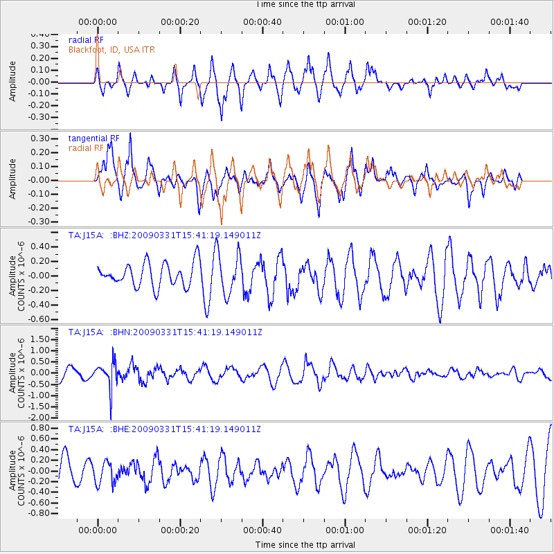
J15A Blackfoot, ID, USA - Earthquake Result Viewer
*The percent match for this event was below the threshold and hence no stack was calculated.
| Earthquake location: |
Mariana Islands |
| Earthquake latitude/longitude: |
18.3/145.7 |
| Earthquake time(UTC): |
2009/03/31 (090) 15:29:31 GMT |
| Earthquake Depth: |
188 km |
| Earthquake Magnitude: |
5.5 MW, 5.4 MB, 5.4 MW |
| Earthquake Catalog/Contributor: |
WHDF/NEIC |
|
| Network: |
TA USArray Transportable Network (new EarthScope stations) |
| Station: |
J15A Blackfoot, ID, USA |
| Lat/Lon: |
43.40 N/112.43 W |
| Elevation: |
1497 m |
|
| Distance: |
85.9 deg |
| Az: |
45.658 deg |
| Baz: |
291.231 deg |
| Ray Param: |
$rayparam |
*The percent match for this event was below the threshold and hence was not used in the summary stack. |
|
| Radial Match: |
60.270733 % |
| Radial Bump: |
400 |
| Transverse Match: |
67.86315 % |
| Transverse Bump: |
400 |
| SOD ConfigId: |
2658 |
| Insert Time: |
2010-03-06 21:57:38.405 +0000 |
| GWidth: |
2.5 |
| Max Bumps: |
400 |
| Tol: |
0.001 |
|
Signal To Noise
| Channel | StoN | STA | LTA |
| TA:J15A: :BHN:20090331T15:41:19.149011Z | 2.3613243 | 5.7462427E-7 | 2.433483E-7 |
| TA:J15A: :BHE:20090331T15:41:19.149011Z | 0.77888906 | 2.1016344E-7 | 2.6982462E-7 |
| TA:J15A: :BHZ:20090331T15:41:19.149011Z | 1.7186954 | 2.7702347E-7 | 1.6118241E-7 |
| Arrivals |
| Ps | |
| PpPs | |
| PsPs/PpSs | |


