You are here: Home > Network List > TA - USArray Transportable Network (new EarthScope stations) Stations List
> Station F18K Selawik, AK, USA > Earthquake Result Viewer
F18K Selawik, AK, USA - Earthquake Result Viewer
| Earthquake location: |
Solomon Islands |
| Earthquake latitude/longitude: |
-6.9/160.1 |
| Earthquake time(UTC): |
2019/05/03 (123) 07:25:29 GMT |
| Earthquake Depth: |
10 km |
| Earthquake Magnitude: |
6.1 Mww |
| Earthquake Catalog/Contributor: |
NEIC PDE/us |
|
| Network: |
TA USArray Transportable Network (new EarthScope stations) |
| Station: |
F18K Selawik, AK, USA |
| Lat/Lon: |
66.60 N/159.65 W |
| Elevation: |
27 m |
|
| Distance: |
78.9 deg |
| Az: |
15.242 deg |
| Baz: |
220.805 deg |
| Ray Param: |
0.049337395 |
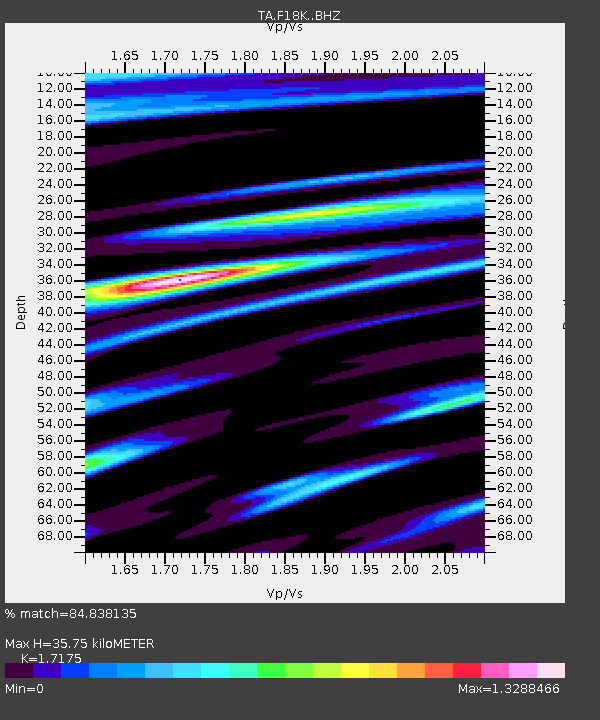
| Estimated Moho Depth: |
35.75 km |
| Estimated Crust Vp/Vs: |
1.72 |
| Assumed Crust Vp: |
6.577 km/s |
| Estimated Crust Vs: |
3.829 km/s |
| Estimated Crust Poisson's Ratio: |
0.24 |
|
| Radial Match: |
84.838135 % |
| Radial Bump: |
400 |
| Transverse Match: |
62.944798 % |
| Transverse Bump: |
400 |
| SOD ConfigId: |
18252611 |
| Insert Time: |
2019-05-17 07:31:34.431 +0000 |
| GWidth: |
2.5 |
| Max Bumps: |
400 |
| Tol: |
0.001 |
|

Signal To Noise
| Channel | StoN | STA | LTA |
| TA:F18K: :BHZ:20190503T07:37:01.250004Z | 6.581133 | 7.8896284E-7 | 1.1988253E-7 |
| TA:F18K: :BHN:20190503T07:37:01.250004Z | 1.7332655 | 3.105831E-7 | 1.7918956E-7 |
| TA:F18K: :BHE:20190503T07:37:01.250004Z | 0.84498364 | 1.0889371E-7 | 1.2887078E-7 |
| Arrivals |
| Ps | 4.0 SECOND |
| PpPs | 14 SECOND |
| PsPs/PpSs | 18 SECOND |


