You are here: Home > Network List > TA - USArray Transportable Network (new EarthScope stations) Stations List
> Station H21K Melozitna River, AK, USA > Earthquake Result Viewer
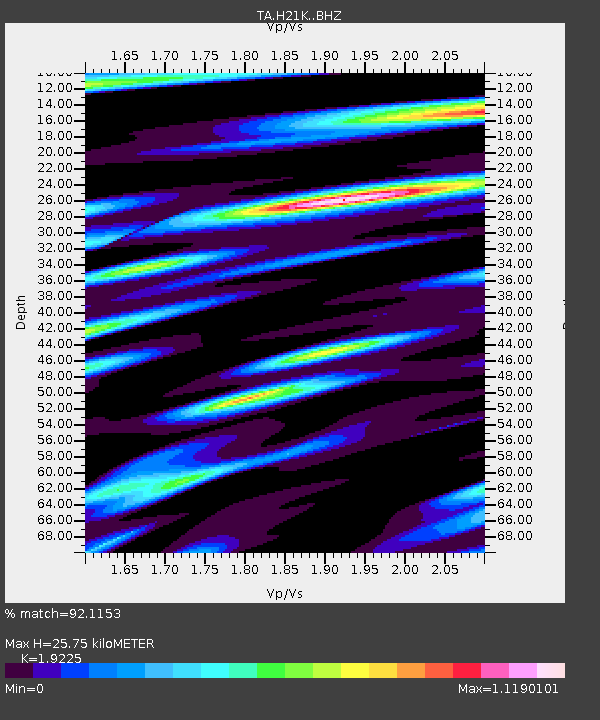
H21K Melozitna River, AK, USA - Earthquake Result Viewer
| Earthquake location: |
Solomon Islands |
| Earthquake latitude/longitude: |
-6.9/160.1 |
| Earthquake time(UTC): |
2019/05/03 (123) 07:25:29 GMT |
| Earthquake Depth: |
10 km |
| Earthquake Magnitude: |
6.1 Mww |
| Earthquake Catalog/Contributor: |
NEIC PDE/us |
|
| Network: |
TA USArray Transportable Network (new EarthScope stations) |
| Station: |
H21K Melozitna River, AK, USA |
| Lat/Lon: |
65.66 N/152.80 W |
| Elevation: |
520 m |
|
| Distance: |
80.1 deg |
| Az: |
17.943 deg |
| Baz: |
227.552 deg |
| Ray Param: |
0.048473693 |
| Estimated Moho Depth: |
25.75 km |
| Estimated Crust Vp/Vs: |
1.92 |
| Assumed Crust Vp: |
6.566 km/s |
| Estimated Crust Vs: |
3.415 km/s |
| Estimated Crust Poisson's Ratio: |
0.31 |
|
| Radial Match: |
92.1153 % |
| Radial Bump: |
400 |
| Transverse Match: |
72.84107 % |
| Transverse Bump: |
400 |
| SOD ConfigId: |
18252611 |
| Insert Time: |
2019-05-17 07:31:54.786 +0000 |
| GWidth: |
2.5 |
| Max Bumps: |
400 |
| Tol: |
0.001 |
|

Signal To Noise
| Channel | StoN | STA | LTA |
| TA:H21K: :BHZ:20190503T07:37:08.075017Z | 9.868281 | 6.9555375E-7 | 7.048378E-8 |
| TA:H21K: :BHN:20190503T07:37:08.075017Z | 4.074896 | 2.0724421E-7 | 5.085877E-8 |
| TA:H21K: :BHE:20190503T07:37:08.075017Z | 4.118084 | 2.5884083E-7 | 6.285467E-8 |
| Arrivals |
| Ps | 3.7 SECOND |
| PpPs | 11 SECOND |
| PsPs/PpSs | 15 SECOND |


