You are here: Home > Network List > TA - USArray Transportable Network (new EarthScope stations) Stations List
> Station J17K VABM Dome, AK, USA > Earthquake Result Viewer
J17K VABM Dome, AK, USA - Earthquake Result Viewer
| Earthquake location: |
Solomon Islands |
| Earthquake latitude/longitude: |
-6.9/160.1 |
| Earthquake time(UTC): |
2019/05/03 (123) 07:25:29 GMT |
| Earthquake Depth: |
10 km |
| Earthquake Magnitude: |
6.1 Mww |
| Earthquake Catalog/Contributor: |
NEIC PDE/us |
|
| Network: |
TA USArray Transportable Network (new EarthScope stations) |
| Station: |
J17K VABM Dome, AK, USA |
| Lat/Lon: |
63.40 N/159.08 W |
| Elevation: |
323 m |
|
| Distance: |
76.6 deg |
| Az: |
17.603 deg |
| Baz: |
221.825 deg |
| Ray Param: |
0.050864737 |
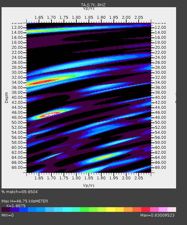
| Estimated Moho Depth: |
46.75 km |
| Estimated Crust Vp/Vs: |
1.69 |
| Assumed Crust Vp: |
6.276 km/s |
| Estimated Crust Vs: |
3.719 km/s |
| Estimated Crust Poisson's Ratio: |
0.23 |
|
| Radial Match: |
89.6504 % |
| Radial Bump: |
400 |
| Transverse Match: |
79.38427 % |
| Transverse Bump: |
400 |
| SOD ConfigId: |
18252611 |
| Insert Time: |
2019-05-17 07:32:05.197 +0000 |
| GWidth: |
2.5 |
| Max Bumps: |
400 |
| Tol: |
0.001 |
|

Signal To Noise
| Channel | StoN | STA | LTA |
| TA:J17K: :BHZ:20190503T07:36:48.700017Z | 13.352185 | 1.1458462E-6 | 8.581713E-8 |
| TA:J17K: :BHN:20190503T07:36:48.700017Z | 5.596314 | 3.5868774E-7 | 6.409357E-8 |
| TA:J17K: :BHE:20190503T07:36:48.700017Z | 3.4625359 | 3.5748536E-7 | 1.0324379E-7 |
| Arrivals |
| Ps | 5.3 SECOND |
| PpPs | 19 SECOND |
| PsPs/PpSs | 25 SECOND |


