You are here: Home > Network List > TA - USArray Transportable Network (new EarthScope stations) Stations List
> Station K20K Telida, AK, USA > Earthquake Result Viewer
K20K Telida, AK, USA - Earthquake Result Viewer
| Earthquake location: |
Solomon Islands |
| Earthquake latitude/longitude: |
-6.9/160.1 |
| Earthquake time(UTC): |
2019/05/03 (123) 07:25:29 GMT |
| Earthquake Depth: |
10 km |
| Earthquake Magnitude: |
6.1 Mww |
| Earthquake Catalog/Contributor: |
NEIC PDE/us |
|
| Network: |
TA USArray Transportable Network (new EarthScope stations) |
| Station: |
K20K Telida, AK, USA |
| Lat/Lon: |
63.36 N/154.07 W |
| Elevation: |
548 m |
|
| Distance: |
78.2 deg |
| Az: |
19.287 deg |
| Baz: |
226.664 deg |
| Ray Param: |
0.04981983 |
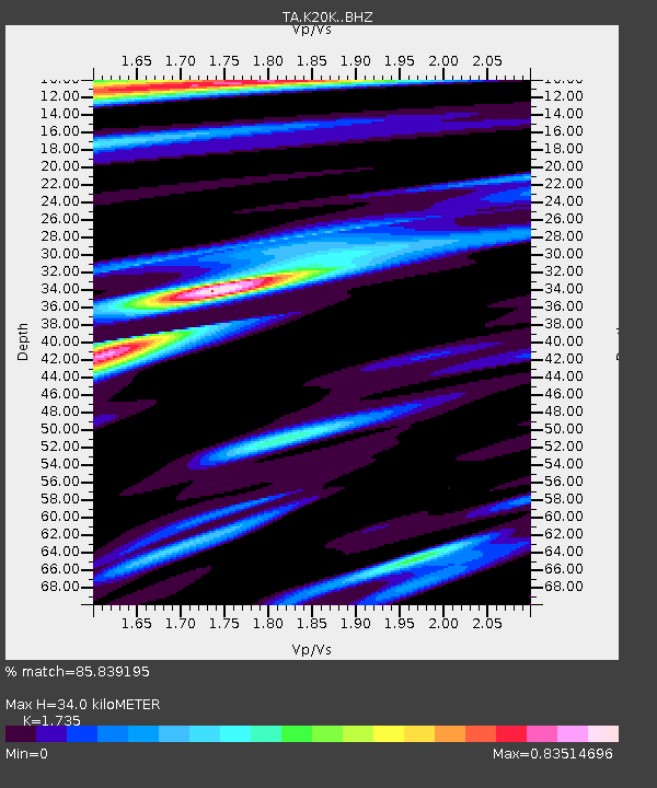
| Estimated Moho Depth: |
34.0 km |
| Estimated Crust Vp/Vs: |
1.74 |
| Assumed Crust Vp: |
6.438 km/s |
| Estimated Crust Vs: |
3.711 km/s |
| Estimated Crust Poisson's Ratio: |
0.25 |
|
| Radial Match: |
85.839195 % |
| Radial Bump: |
400 |
| Transverse Match: |
82.57164 % |
| Transverse Bump: |
400 |
| SOD ConfigId: |
18252611 |
| Insert Time: |
2019-05-17 07:32:10.359 +0000 |
| GWidth: |
2.5 |
| Max Bumps: |
400 |
| Tol: |
0.001 |
|

Signal To Noise
| Channel | StoN | STA | LTA |
| TA:K20K: :BHZ:20190503T07:36:57.325017Z | 16.352587 | 1.1106798E-6 | 6.792074E-8 |
| TA:K20K: :BHN:20190503T07:36:57.325017Z | 2.467056 | 1.8721153E-7 | 7.5884586E-8 |
| TA:K20K: :BHE:20190503T07:36:57.325017Z | 2.483818 | 1.9226918E-7 | 7.740872E-8 |
| Arrivals |
| Ps | 4.0 SECOND |
| PpPs | 14 SECOND |
| PsPs/PpSs | 18 SECOND |


