You are here: Home > Network List > II - Global Seismograph Network (GSN - IRIS/IDA) Stations List
> Station WRAB Tennant Creek, NT, Australia > Earthquake Result Viewer
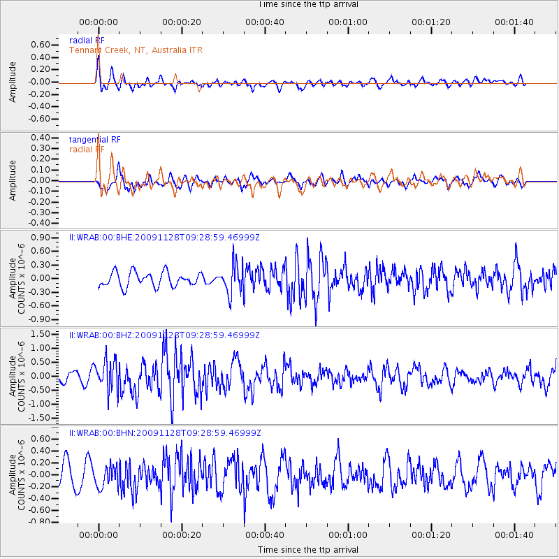
WRAB Tennant Creek, NT, Australia - Earthquake Result Viewer
*The percent match for this event was below the threshold and hence no stack was calculated.
| Earthquake location: |
Kermadec Islands, New Zealand |
| Earthquake latitude/longitude: |
-29.2/-177.0 |
| Earthquake time(UTC): |
2009/11/28 (332) 09:21:17 GMT |
| Earthquake Depth: |
28 km |
| Earthquake Magnitude: |
5.8 MB, 5.8 MS, 6.0 MW, 5.9 MW |
| Earthquake Catalog/Contributor: |
WHDF/NEIC |
|
| Network: |
II Global Seismograph Network (GSN - IRIS/IDA) |
| Station: |
WRAB Tennant Creek, NT, Australia |
| Lat/Lon: |
19.93 S/134.36 E |
| Elevation: |
366 m |
|
| Distance: |
44.9 deg |
| Az: |
270.465 deg |
| Baz: |
111.7 deg |
| Ray Param: |
$rayparam |
*The percent match for this event was below the threshold and hence was not used in the summary stack. |
|
| Radial Match: |
76.7912 % |
| Radial Bump: |
400 |
| Transverse Match: |
72.03409 % |
| Transverse Bump: |
400 |
| SOD ConfigId: |
1 |
| Insert Time: |
2010-02-19 01:17:23.800 +0000 |
| GWidth: |
2.5 |
| Max Bumps: |
400 |
| Tol: |
0.001 |
|
Signal To Noise
| Channel | StoN | STA | LTA |
| II:WRAB:00:BHZ:20091128T09:28:59.46999Z | 3.6331422 | 5.243247E-7 | 1.4431716E-7 |
| II:WRAB:00:BHN:20091128T09:28:59.46999Z | 1.2141355 | 1.7611619E-7 | 1.4505481E-7 |
| II:WRAB:00:BHE:20091128T09:28:59.46999Z | 2.0365186 | 3.1906995E-7 | 1.5667422E-7 |
| Arrivals |
| Ps | |
| PpPs | |
| PsPs/PpSs | |


