You are here: Home > Network List > TA - USArray Transportable Network (new EarthScope stations) Stations List
> Station N16K Nishlik Lake, AK, USA > Earthquake Result Viewer
N16K Nishlik Lake, AK, USA - Earthquake Result Viewer
| Earthquake location: |
Solomon Islands |
| Earthquake latitude/longitude: |
-6.9/160.1 |
| Earthquake time(UTC): |
2019/05/03 (123) 07:25:29 GMT |
| Earthquake Depth: |
10 km |
| Earthquake Magnitude: |
6.1 Mww |
| Earthquake Catalog/Contributor: |
NEIC PDE/us |
|
| Network: |
TA USArray Transportable Network (new EarthScope stations) |
| Station: |
N16K Nishlik Lake, AK, USA |
| Lat/Lon: |
60.47 N/158.77 W |
| Elevation: |
582 m |
|
| Distance: |
74.6 deg |
| Az: |
19.75 deg |
| Baz: |
222.632 deg |
| Ray Param: |
0.05225367 |
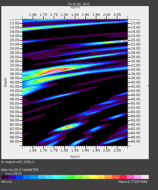
| Estimated Moho Depth: |
20.0 km |
| Estimated Crust Vp/Vs: |
2.10 |
| Assumed Crust Vp: |
6.276 km/s |
| Estimated Crust Vs: |
2.992 km/s |
| Estimated Crust Poisson's Ratio: |
0.35 |
|
| Radial Match: |
92.34513 % |
| Radial Bump: |
400 |
| Transverse Match: |
79.72207 % |
| Transverse Bump: |
400 |
| SOD ConfigId: |
18252611 |
| Insert Time: |
2019-05-17 07:32:29.055 +0000 |
| GWidth: |
2.5 |
| Max Bumps: |
400 |
| Tol: |
0.001 |
|

Signal To Noise
| Channel | StoN | STA | LTA |
| TA:N16K: :BHZ:20190503T07:36:36.84998Z | 12.089327 | 1.4192251E-6 | 1.1739488E-7 |
| TA:N16K: :BHN:20190503T07:36:36.84998Z | 4.1044917 | 3.638566E-7 | 8.864839E-8 |
| TA:N16K: :BHE:20190503T07:36:36.84998Z | 6.3368387 | 5.8308905E-7 | 9.201576E-8 |
| Arrivals |
| Ps | 3.6 SECOND |
| PpPs | 9.6 SECOND |
| PsPs/PpSs | 13 SECOND |


