You are here: Home > Network List > TA - USArray Transportable Network (new EarthScope stations) Stations List
> Station J15A Blackfoot, ID, USA > Earthquake Result Viewer
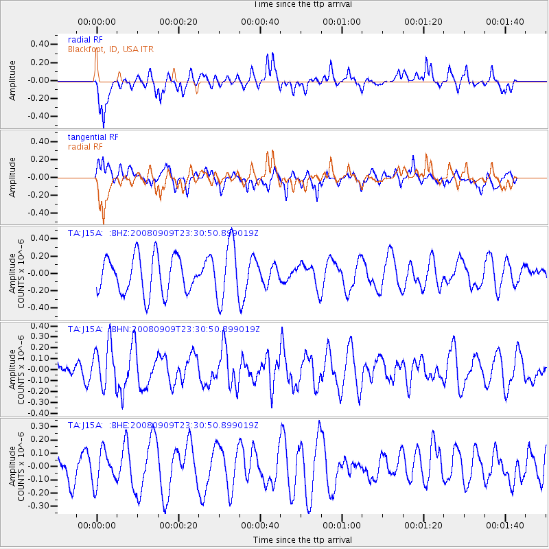
J15A Blackfoot, ID, USA - Earthquake Result Viewer
*The percent match for this event was below the threshold and hence no stack was calculated.
| Earthquake location: |
Santa Cruz Islands |
| Earthquake latitude/longitude: |
-11.8/166.5 |
| Earthquake time(UTC): |
2008/09/09 (253) 23:18:26 GMT |
| Earthquake Depth: |
99 km |
| Earthquake Magnitude: |
5.6 MW, 5.4 MB, 5.6 MW |
| Earthquake Catalog/Contributor: |
WHDF/NEIC |
|
| Network: |
TA USArray Transportable Network (new EarthScope stations) |
| Station: |
J15A Blackfoot, ID, USA |
| Lat/Lon: |
43.40 N/112.43 W |
| Elevation: |
1497 m |
|
| Distance: |
91.6 deg |
| Az: |
46.08 deg |
| Baz: |
255.38 deg |
| Ray Param: |
$rayparam |
*The percent match for this event was below the threshold and hence was not used in the summary stack. |
|
| Radial Match: |
41.929653 % |
| Radial Bump: |
337 |
| Transverse Match: |
47.84687 % |
| Transverse Bump: |
400 |
| SOD ConfigId: |
2560 |
| Insert Time: |
2010-03-06 21:57:58.023 +0000 |
| GWidth: |
2.5 |
| Max Bumps: |
400 |
| Tol: |
0.001 |
|
Signal To Noise
| Channel | StoN | STA | LTA |
| TA:J15A: :BHN:20080909T23:30:50.899019Z | 2.4697385 | 2.0281908E-7 | 8.212169E-8 |
| TA:J15A: :BHE:20080909T23:30:50.899019Z | 0.9293043 | 1.2646123E-7 | 1.3608161E-7 |
| TA:J15A: :BHZ:20080909T23:30:50.899019Z | 1.6300846 | 3.463634E-7 | 2.1248185E-7 |
| Arrivals |
| Ps | |
| PpPs | |
| PsPs/PpSs | |


