You are here: Home > Network List > UU - University of Utah Regional Network Stations List
> Station FOR1 Milford Southwest, UT, USA > Earthquake Result Viewer
FOR1 Milford Southwest, UT, USA - Earthquake Result Viewer
| Earthquake location: |
Solomon Islands |
| Earthquake latitude/longitude: |
-6.9/160.1 |
| Earthquake time(UTC): |
2019/05/03 (123) 07:25:29 GMT |
| Earthquake Depth: |
10 km |
| Earthquake Magnitude: |
6.1 Mww |
| Earthquake Catalog/Contributor: |
NEIC PDE/us |
|
| Network: |
UU University of Utah Regional Network |
| Station: |
FOR1 Milford Southwest, UT, USA |
| Lat/Lon: |
38.37 N/113.09 W |
| Elevation: |
1642 m |
|
| Distance: |
91.7 deg |
| Az: |
51.738 deg |
| Baz: |
262.606 deg |
| Ray Param: |
0.04156321 |
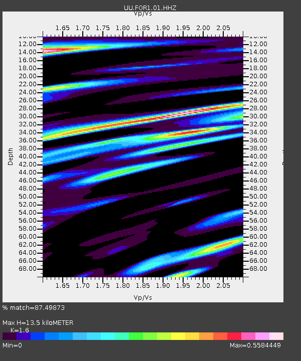
| Estimated Moho Depth: |
13.5 km |
| Estimated Crust Vp/Vs: |
1.60 |
| Assumed Crust Vp: |
6.276 km/s |
| Estimated Crust Vs: |
3.922 km/s |
| Estimated Crust Poisson's Ratio: |
0.18 |
|
| Radial Match: |
87.49873 % |
| Radial Bump: |
400 |
| Transverse Match: |
81.69898 % |
| Transverse Bump: |
366 |
| SOD ConfigId: |
18252611 |
| Insert Time: |
2019-05-17 07:33:36.653 +0000 |
| GWidth: |
2.5 |
| Max Bumps: |
400 |
| Tol: |
0.001 |
|

Signal To Noise
| Channel | StoN | STA | LTA |
| UU:FOR1:01:HHZ:20190503T07:38:05.34998Z | 14.834197 | 3.4377248E-8 | 2.3174325E-9 |
| UU:FOR1:01:HHN:20190503T07:38:05.34998Z | 2.8187025 | 4.0224215E-9 | 1.4270474E-9 |
| UU:FOR1:01:HHE:20190503T07:38:05.34998Z | 8.14466 | 9.251561E-9 | 1.135905E-9 |
| Arrivals |
| Ps | 1.3 SECOND |
| PpPs | 5.5 SECOND |
| PsPs/PpSs | 6.8 SECOND |


