You are here: Home > Network List > TS - TERRAscope (Southern California Seismic Network) Stations List
> Station DGR Domenigoni Valley Reservior, California, USA > Earthquake Result Viewer
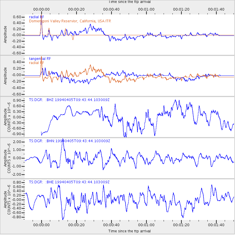
DGR Domenigoni Valley Reservior, California, USA - Earthquake Result Viewer
*The percent match for this event was below the threshold and hence no stack was calculated.
| Earthquake location: |
Andreanof Islands, Aleutian Is. |
| Earthquake latitude/longitude: |
51.3/-178.1 |
| Earthquake time(UTC): |
1994/04/05 (095) 09:35:46 GMT |
| Earthquake Depth: |
33 km |
| Earthquake Magnitude: |
5.8 MB, 5.9 MS, 6.2 UNKNOWN, 6.0 MW |
| Earthquake Catalog/Contributor: |
WHDF/NEIC |
|
| Network: |
TS TERRAscope (Southern California Seismic Network) |
| Station: |
DGR Domenigoni Valley Reservior, California, USA |
| Lat/Lon: |
33.65 N/117.01 W |
| Elevation: |
700 m |
|
| Distance: |
47.0 deg |
| Az: |
87.446 deg |
| Baz: |
311.251 deg |
| Ray Param: |
$rayparam |
*The percent match for this event was below the threshold and hence was not used in the summary stack. |
|
| Radial Match: |
41.154488 % |
| Radial Bump: |
400 |
| Transverse Match: |
35.4342 % |
| Transverse Bump: |
400 |
| SOD ConfigId: |
4480 |
| Insert Time: |
2010-02-26 14:11:30.864 +0000 |
| GWidth: |
2.5 |
| Max Bumps: |
400 |
| Tol: |
0.001 |
|
Signal To Noise
| Channel | StoN | STA | LTA |
| TS:DGR: :BHN:19940405T09:43:44.103009Z | 2.4049082 | 4.973389E-7 | 2.068016E-7 |
| TS:DGR: :BHE:19940405T09:43:44.103009Z | 0.8748794 | 2.1653065E-7 | 2.4749772E-7 |
| TS:DGR: :BHZ:19940405T09:43:44.103009Z | 0.84110796 | 3.5596037E-7 | 4.2320417E-7 |
| Arrivals |
| Ps | |
| PpPs | |
| PsPs/PpSs | |


