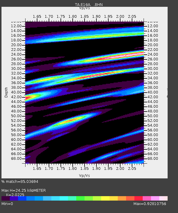
E16A East Helena, MT, USA - Earthquake Result Viewer
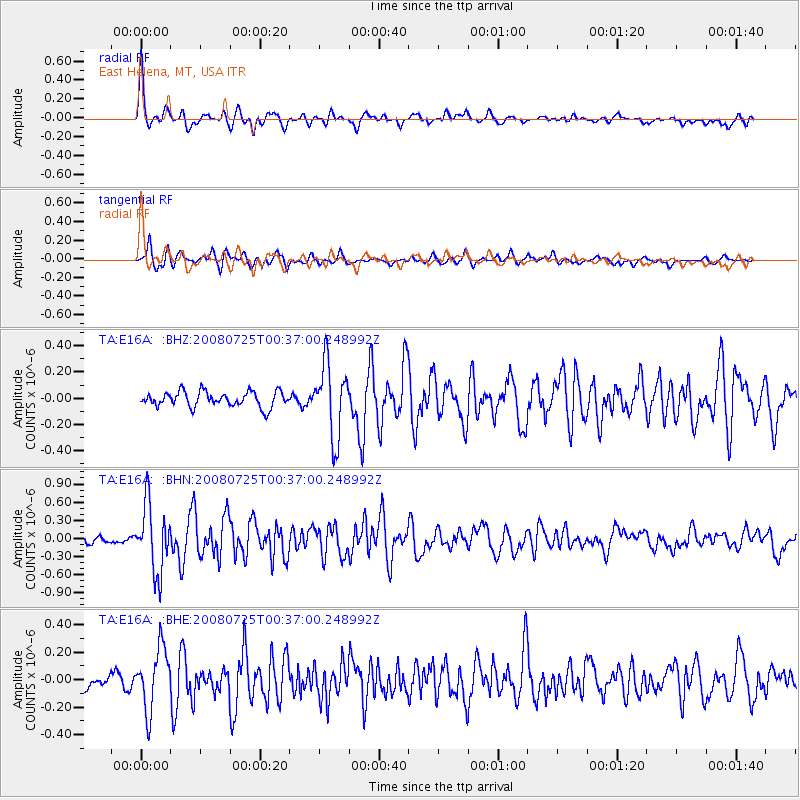
Earthquake location: Rat Islands, Aleutian Islands
Earthquake latitude/longitude: 51.3/179.0
Earthquake time(UTC): 2008/07/25 (207) 00:29:22 GMT
Earthquake Depth: 21 km
Earthquake Magnitude: 5.7 MB, 5.5 MS, 5.9 MW, 5.9 MW
Earthquake Catalog/Contributor: WHDF/NEIC
Network: TA USArray Transportable Network (new EarthScope stations)
Station: E16A East Helena, MT, USA
Lat/Lon: 46.53 N/111.68 W
Elevation: 1398 m
Distance: 44.3 deg
Az: 67.704 deg
Baz: 302.672 deg
Ray Param: 0.07198522
Estimated Moho Depth: 24.25 km
Estimated Crust Vp/Vs: 2.02
Assumed Crust Vp: 6.306 km/s
Estimated Crust Vs: 3.118 km/s
Estimated Crust Poisson's Ratio: 0.34
Radial Match: 85.03694 %
Radial Bump: 400
Transverse Match: 83.14331 %
Transverse Bump: 400
SOD ConfigId: 2504
Insert Time: 2010-03-06 21:58:20.197 +0000
GWidth: 2.5
Max Bumps: 400
Tol: 0.001

Signal To Noise

ChannelStoNSTALTA
TA:E16A: :BHN:20080725T00:37:00.248992Z12.4254895.546529E-74.4638313E-8
TA:E16A: :BHE:20080725T00:37:00.248992Z4.0092852.2357617E-75.57646E-8
TA:E16A: :BHZ:20080725T00:37:00.248992Z4.82027962.7685172E-75.7434782E-8
Arrivals
Ps4.2 SECOND
PpPs11 SECOND
PsPs/PpSs15 SECOND