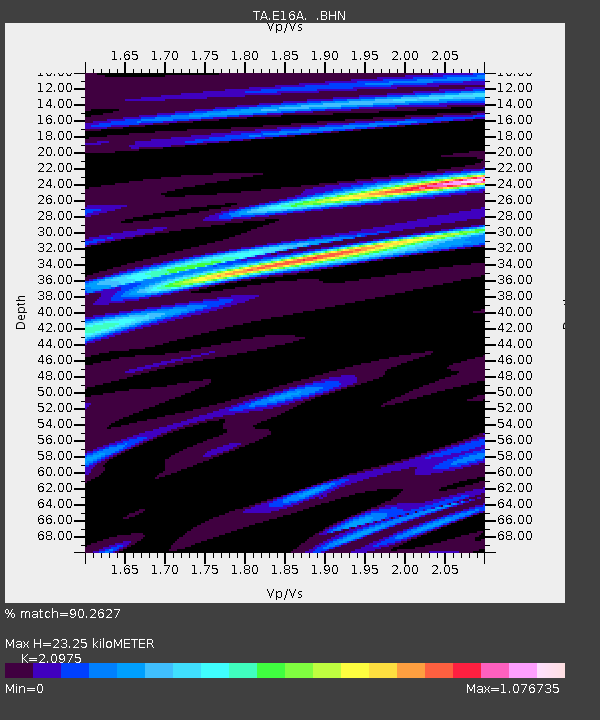
E16A East Helena, MT, USA - Earthquake Result Viewer
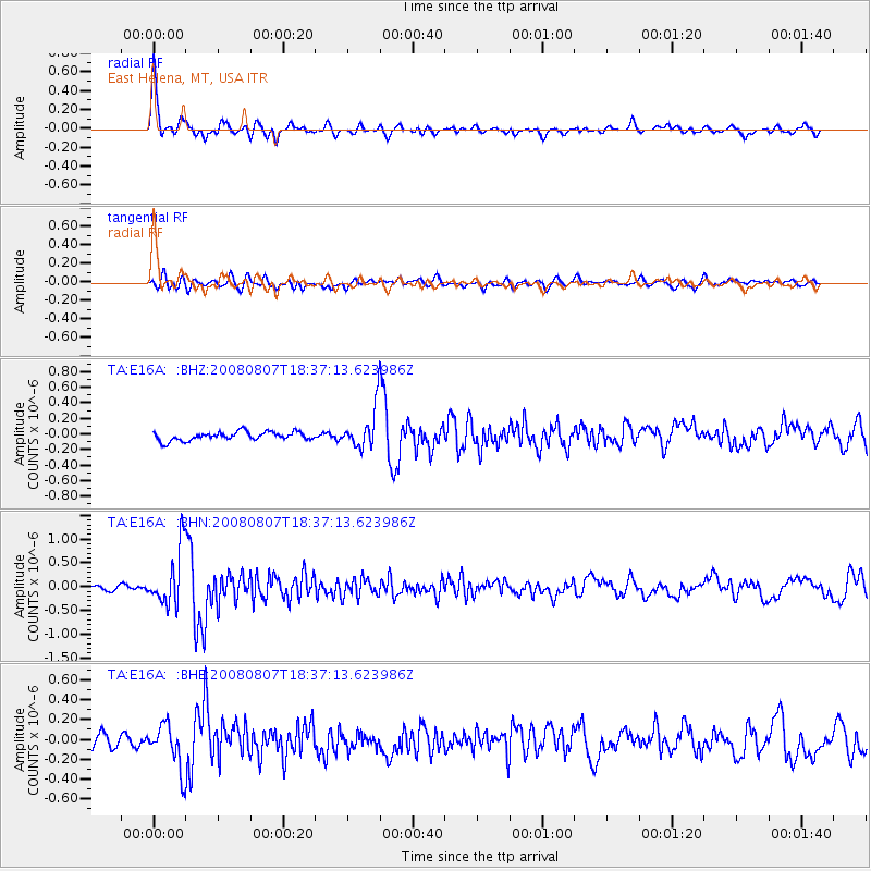
Earthquake location: Andreanof Islands, Aleutian Is.
Earthquake latitude/longitude: 52.2/-175.7
Earthquake time(UTC): 2008/08/07 (220) 18:30:03 GMT
Earthquake Depth: 12 km
Earthquake Magnitude: 5.6 MB, 5.5 MS, 5.8 MW, 5.8 MW
Earthquake Catalog/Contributor: WHDF/NEIC
Network: TA USArray Transportable Network (new EarthScope stations)
Station: E16A East Helena, MT, USA
Lat/Lon: 46.53 N/111.68 W
Elevation: 1398 m
Distance: 40.8 deg
Az: 71.575 deg
Baz: 302.219 deg
Ray Param: 0.07416091
Estimated Moho Depth: 23.25 km
Estimated Crust Vp/Vs: 2.10
Assumed Crust Vp: 6.306 km/s
Estimated Crust Vs: 3.006 km/s
Estimated Crust Poisson's Ratio: 0.35
Radial Match: 90.2627 %
Radial Bump: 400
Transverse Match: 59.37363 %
Transverse Bump: 400
SOD ConfigId: 2504
Insert Time: 2010-03-06 21:58:24.603 +0000
GWidth: 2.5
Max Bumps: 400
Tol: 0.001

Signal To Noise

ChannelStoNSTALTA
TA:E16A: :BHN:20080807T18:37:13.623986Z9.4835555.9060125E-76.227636E-8
TA:E16A: :BHE:20080807T18:37:13.623986Z3.1771932.1969636E-76.9147944E-8
TA:E16A: :BHZ:20080807T18:37:13.623986Z4.8413222.6583447E-75.490948E-8
Arrivals
Ps4.3 SECOND
PpPs11 SECOND
PsPs/PpSs15 SECOND