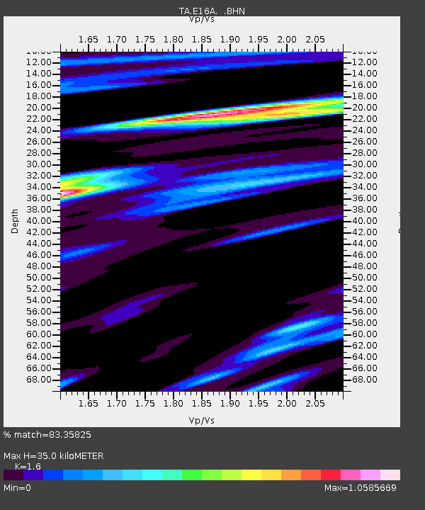
E16A East Helena, MT, USA - Earthquake Result Viewer
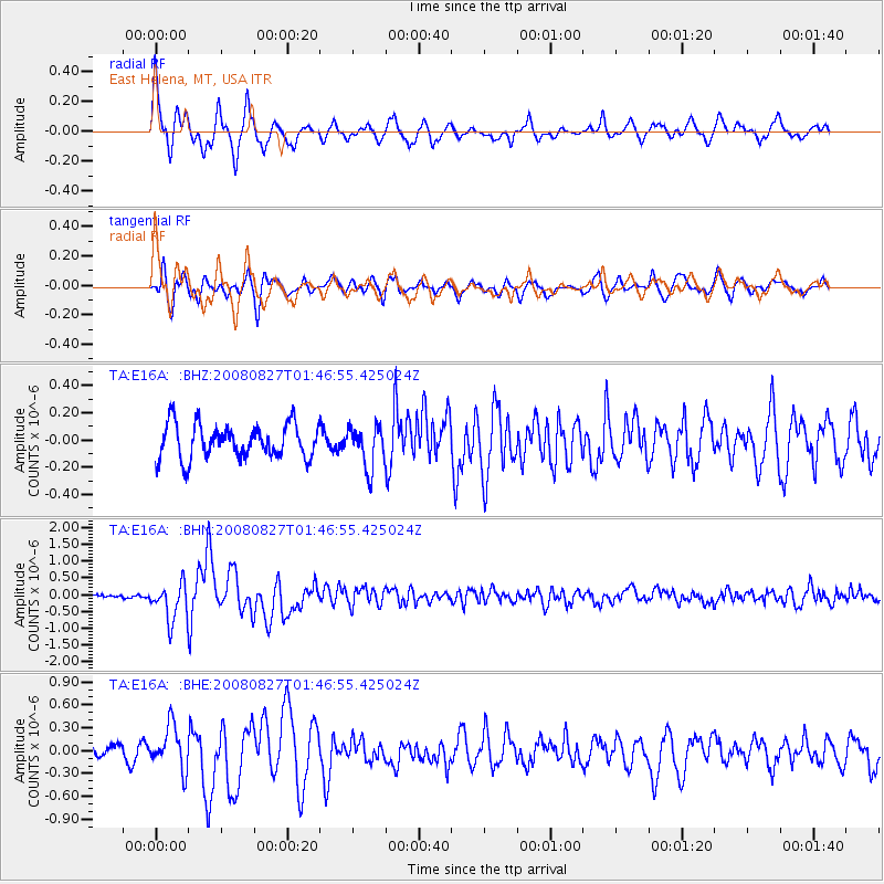
Earthquake location: Lake Baykal Region, Russia
Earthquake latitude/longitude: 51.6/104.2
Earthquake time(UTC): 2008/08/27 (240) 01:35:32 GMT
Earthquake Depth: 16 km
Earthquake Magnitude: 5.8 MB, 6.2 MS, 6.2 MW, 6.2 MW
Earthquake Catalog/Contributor: WHDF/NEIC
Network: TA USArray Transportable Network (new EarthScope stations)
Station: E16A East Helena, MT, USA
Lat/Lon: 46.53 N/111.68 W
Elevation: 1398 m
Distance: 77.5 deg
Az: 24.456 deg
Baz: 338.04 deg
Ray Param: 0.05027287
Estimated Moho Depth: 35.0 km
Estimated Crust Vp/Vs: 1.60
Assumed Crust Vp: 6.306 km/s
Estimated Crust Vs: 3.941 km/s
Estimated Crust Poisson's Ratio: 0.18
Radial Match: 83.35825 %
Radial Bump: 373
Transverse Match: 69.04731 %
Transverse Bump: 400
SOD ConfigId: 2504
Insert Time: 2010-03-06 21:58:27.141 +0000
GWidth: 2.5
Max Bumps: 400
Tol: 0.001

Signal To Noise

ChannelStoNSTALTA
TA:E16A: :BHN:20080827T01:46:55.425024Z10.884195.4957235E-75.049272E-8
TA:E16A: :BHE:20080827T01:46:55.425024Z3.34648252.8407925E-78.488891E-8
TA:E16A: :BHZ:20080827T01:46:55.425024Z1.23797461.5477936E-71.2502628E-7
Arrivals
Ps3.4 SECOND
PpPs14 SECOND
PsPs/PpSs17 SECOND