You are here: Home > Network List > TA - USArray Transportable Network (new EarthScope stations) Stations List
> Station E16A East Helena, MT, USA > Earthquake Result Viewer
E16A East Helena, MT, USA - Earthquake Result Viewer
| Earthquake location: |
Vanuatu Islands |
| Earthquake latitude/longitude: |
-14.8/168.0 |
| Earthquake time(UTC): |
2008/11/07 (312) 07:19:35 GMT |
| Earthquake Depth: |
13 km |
| Earthquake Magnitude: |
6.0 MB, 6.3 MS, 6.4 MW, 6.4 MW |
| Earthquake Catalog/Contributor: |
WHDF/NEIC |
|
| Network: |
TA USArray Transportable Network (new EarthScope stations) |
| Station: |
E16A East Helena, MT, USA |
| Lat/Lon: |
46.53 N/111.68 W |
| Elevation: |
1398 m |
|
| Distance: |
94.1 deg |
| Az: |
43.017 deg |
| Baz: |
252.883 deg |
| Ray Param: |
0.04112223 |
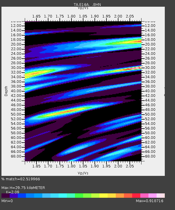
| Estimated Moho Depth: |
29.75 km |
| Estimated Crust Vp/Vs: |
2.09 |
| Assumed Crust Vp: |
6.306 km/s |
| Estimated Crust Vs: |
3.017 km/s |
| Estimated Crust Poisson's Ratio: |
0.35 |
|
| Radial Match: |
82.519966 % |
| Radial Bump: |
334 |
| Transverse Match: |
74.851204 % |
| Transverse Bump: |
400 |
| SOD ConfigId: |
2658 |
| Insert Time: |
2010-03-06 21:58:32.526 +0000 |
| GWidth: |
2.5 |
| Max Bumps: |
400 |
| Tol: |
0.001 |
|

Signal To Noise
| Channel | StoN | STA | LTA |
| TA:E16A: :BHN:20081107T07:32:22.074014Z | 3.059845 | 2.96282E-7 | 9.682908E-8 |
| TA:E16A: :BHE:20081107T07:32:22.074014Z | 1.3543942 | 1.3082271E-7 | 9.659131E-8 |
| TA:E16A: :BHZ:20081107T07:32:22.074014Z | 1.9225991 | 1.2386857E-7 | 6.442767E-8 |
| Arrivals |
| Ps | 5.2 SECOND |
| PpPs | 14 SECOND |
| PsPs/PpSs | 20 SECOND |


