You are here: Home > Network List > TA - USArray Transportable Network (new EarthScope stations) Stations List
> Station E16A East Helena, MT, USA > Earthquake Result Viewer
E16A East Helena, MT, USA - Earthquake Result Viewer
| Earthquake location: |
Central Mid-Atlantic Ridge |
| Earthquake latitude/longitude: |
8.1/-38.7 |
| Earthquake time(UTC): |
2008/09/10 (254) 13:08:14 GMT |
| Earthquake Depth: |
10 km |
| Earthquake Magnitude: |
6.3 MB, 6.5 MS, 6.6 MW, 6.6 MW |
| Earthquake Catalog/Contributor: |
WHDF/NEIC |
|
| Network: |
TA USArray Transportable Network (new EarthScope stations) |
| Station: |
E16A East Helena, MT, USA |
| Lat/Lon: |
46.53 N/111.68 W |
| Elevation: |
1398 m |
|
| Distance: |
72.5 deg |
| Az: |
316.191 deg |
| Baz: |
96.831 deg |
| Ray Param: |
0.0536507 |
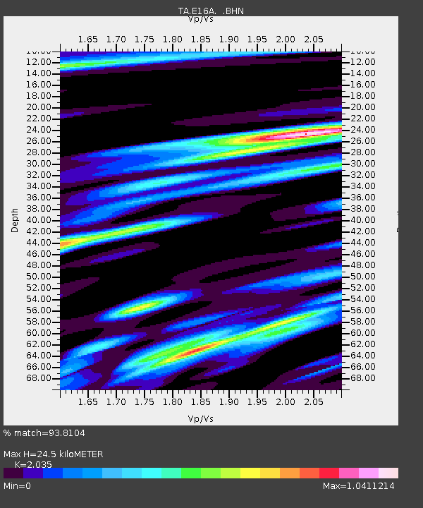
| Estimated Moho Depth: |
24.5 km |
| Estimated Crust Vp/Vs: |
2.04 |
| Assumed Crust Vp: |
6.306 km/s |
| Estimated Crust Vs: |
3.099 km/s |
| Estimated Crust Poisson's Ratio: |
0.34 |
|
| Radial Match: |
93.8104 % |
| Radial Bump: |
400 |
| Transverse Match: |
94.4148 % |
| Transverse Bump: |
383 |
| SOD ConfigId: |
2560 |
| Insert Time: |
2010-03-06 21:58:39.060 +0000 |
| GWidth: |
2.5 |
| Max Bumps: |
400 |
| Tol: |
0.001 |
|
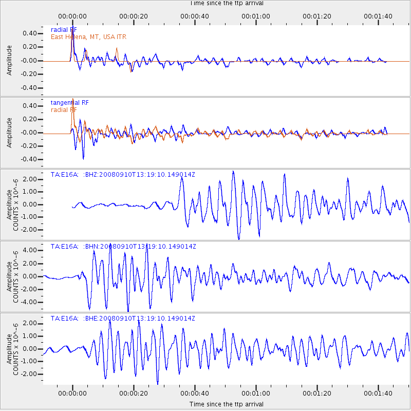
Signal To Noise
| Channel | StoN | STA | LTA |
| TA:E16A: :BHN:20080910T13:19:10.149014Z | 2.380206 | 4.5400958E-7 | 1.9074382E-7 |
| TA:E16A: :BHE:20080910T13:19:10.149014Z | 0.97241235 | 1.5528265E-7 | 1.5968807E-7 |
| TA:E16A: :BHZ:20080910T13:19:10.149014Z | 2.1434247 | 2.4386765E-7 | 1.1377476E-7 |
| Arrivals |
| Ps | 4.1 SECOND |
| PpPs | 11 SECOND |
| PsPs/PpSs | 16 SECOND |


