You are here: Home > Network List > TA - USArray Transportable Network (new EarthScope stations) Stations List
> Station E16A East Helena, MT, USA > Earthquake Result Viewer
E16A East Helena, MT, USA - Earthquake Result Viewer
| Earthquake location: |
Svalbard Region |
| Earthquake latitude/longitude: |
77.1/18.6 |
| Earthquake time(UTC): |
2008/02/21 (052) 02:46:17 GMT |
| Earthquake Depth: |
10 km |
| Earthquake Magnitude: |
5.7 MB, 5.9 MS, 6.1 MW, 6.0 MW |
| Earthquake Catalog/Contributor: |
WHDF/NEIC |
|
| Network: |
TA USArray Transportable Network (new EarthScope stations) |
| Station: |
E16A East Helena, MT, USA |
| Lat/Lon: |
46.53 N/111.68 W |
| Elevation: |
1398 m |
|
| Distance: |
52.8 deg |
| Az: |
318.588 deg |
| Baz: |
12.451 deg |
| Ray Param: |
0.06652502 |
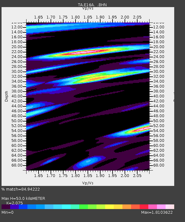
| Estimated Moho Depth: |
53.0 km |
| Estimated Crust Vp/Vs: |
2.08 |
| Assumed Crust Vp: |
6.306 km/s |
| Estimated Crust Vs: |
3.039 km/s |
| Estimated Crust Poisson's Ratio: |
0.35 |
|
| Radial Match: |
84.94222 % |
| Radial Bump: |
400 |
| Transverse Match: |
77.7893 % |
| Transverse Bump: |
400 |
| SOD ConfigId: |
2564 |
| Insert Time: |
2010-03-06 21:58:46.881 +0000 |
| GWidth: |
2.5 |
| Max Bumps: |
400 |
| Tol: |
0.001 |
|

Signal To Noise
| Channel | StoN | STA | LTA |
| TA:E16A: :BHN:20080221T02:55:02.249019Z | 4.1838384 | 9.290682E-7 | 2.2206122E-7 |
| TA:E16A: :BHE:20080221T02:55:02.249019Z | 1.3537813 | 3.2602154E-7 | 2.4082289E-7 |
| TA:E16A: :BHZ:20080221T02:55:02.249019Z | 5.036891 | 1.320073E-6 | 2.620809E-7 |
| Arrivals |
| Ps | 9.5 SECOND |
| PpPs | 25 SECOND |
| PsPs/PpSs | 34 SECOND |


