You are here: Home > Network List > TA - USArray Transportable Network (new EarthScope stations) Stations List
> Station E16A East Helena, MT, USA > Earthquake Result Viewer
E16A East Helena, MT, USA - Earthquake Result Viewer
| Earthquake location: |
Off Coast Of Ecuador |
| Earthquake latitude/longitude: |
1.4/-85.2 |
| Earthquake time(UTC): |
2009/05/10 (130) 01:16:06 GMT |
| Earthquake Depth: |
6.0 km |
| Earthquake Magnitude: |
5.5 MB, 5.7 MS, 6.1 MW, 6.1 MW |
| Earthquake Catalog/Contributor: |
WHDF/NEIC |
|
| Network: |
TA USArray Transportable Network (new EarthScope stations) |
| Station: |
E16A East Helena, MT, USA |
| Lat/Lon: |
46.53 N/111.68 W |
| Elevation: |
1398 m |
|
| Distance: |
50.6 deg |
| Az: |
336.492 deg |
| Baz: |
144.717 deg |
| Ray Param: |
0.0679759 |
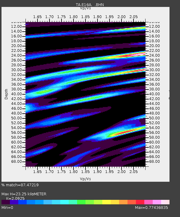
| Estimated Moho Depth: |
23.25 km |
| Estimated Crust Vp/Vs: |
2.09 |
| Assumed Crust Vp: |
6.306 km/s |
| Estimated Crust Vs: |
3.014 km/s |
| Estimated Crust Poisson's Ratio: |
0.35 |
|
| Radial Match: |
87.47219 % |
| Radial Bump: |
334 |
| Transverse Match: |
79.995026 % |
| Transverse Bump: |
375 |
| SOD ConfigId: |
2760 |
| Insert Time: |
2010-03-06 21:59:26.316 +0000 |
| GWidth: |
2.5 |
| Max Bumps: |
400 |
| Tol: |
0.001 |
|

Signal To Noise
| Channel | StoN | STA | LTA |
| TA:E16A: :BHN:20090510T01:24:35.324014Z | 5.756175 | 4.0674348E-7 | 7.066211E-8 |
| TA:E16A: :BHE:20090510T01:24:35.324014Z | 3.753536 | 2.1484976E-7 | 5.7239298E-8 |
| TA:E16A: :BHZ:20090510T01:24:35.324014Z | 2.3936458 | 1.03736305E-7 | 4.3338204E-8 |
| Arrivals |
| Ps | 4.2 SECOND |
| PpPs | 11 SECOND |
| PsPs/PpSs | 15 SECOND |


