You are here: Home > Network List > TA - USArray Transportable Network (new EarthScope stations) Stations List
> Station E16A East Helena, MT, USA > Earthquake Result Viewer
E16A East Helena, MT, USA - Earthquake Result Viewer
| Earthquake location: |
Andreanof Islands, Aleutian Is. |
| Earthquake latitude/longitude: |
51.2/-179.0 |
| Earthquake time(UTC): |
2007/12/21 (355) 07:23:35 GMT |
| Earthquake Depth: |
30 km |
| Earthquake Magnitude: |
5.7 MB, 5.5 ML |
| Earthquake Catalog/Contributor: |
WHDF/NEIC |
|
| Network: |
TA USArray Transportable Network (new EarthScope stations) |
| Station: |
E16A East Helena, MT, USA |
| Lat/Lon: |
46.53 N/111.68 W |
| Elevation: |
1398 m |
|
| Distance: |
43.1 deg |
| Az: |
68.743 deg |
| Baz: |
301.947 deg |
| Ray Param: |
0.07269802 |
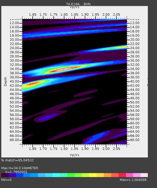
| Estimated Moho Depth: |
34.0 km |
| Estimated Crust Vp/Vs: |
1.80 |
| Assumed Crust Vp: |
6.306 km/s |
| Estimated Crust Vs: |
3.513 km/s |
| Estimated Crust Poisson's Ratio: |
0.27 |
|
| Radial Match: |
85.84532 % |
| Radial Bump: |
351 |
| Transverse Match: |
60.26242 % |
| Transverse Bump: |
400 |
| SOD ConfigId: |
2564 |
| Insert Time: |
2010-03-06 21:59:30.351 +0000 |
| GWidth: |
2.5 |
| Max Bumps: |
400 |
| Tol: |
0.001 |
|
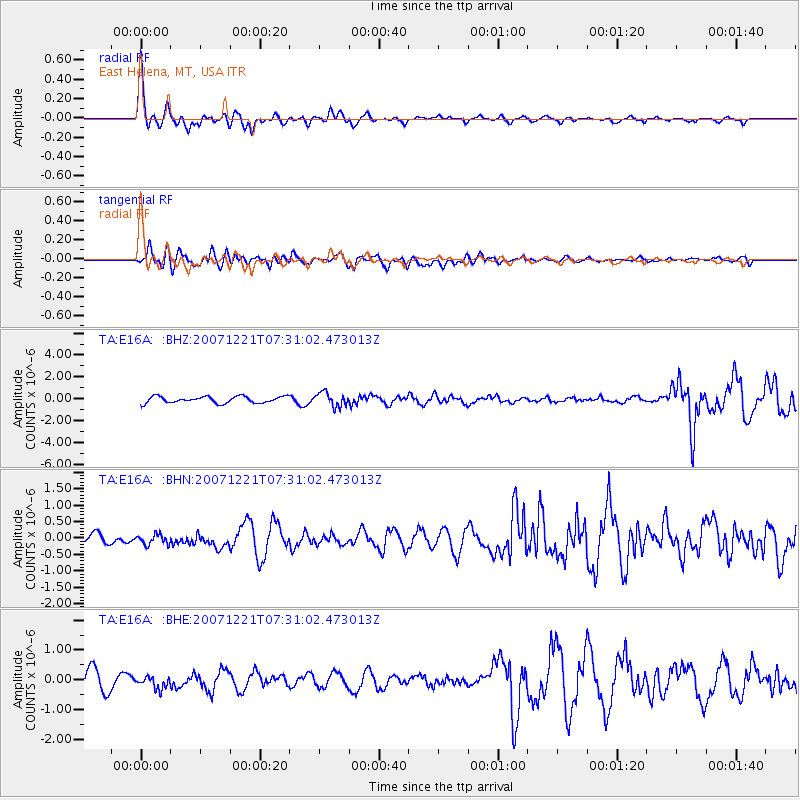
Signal To Noise
| Channel | StoN | STA | LTA |
| TA:E16A: :BHN:20071221T07:31:02.473013Z | 0.783834 | 1.4988262E-7 | 1.9121731E-7 |
| TA:E16A: :BHE:20071221T07:31:02.473013Z | 0.71631163 | 2.1129708E-7 | 2.9497926E-7 |
| TA:E16A: :BHZ:20071221T07:31:02.473013Z | 2.1430523 | 6.373658E-7 | 2.974103E-7 |
| Arrivals |
| Ps | 4.6 SECOND |
| PpPs | 14 SECOND |
| PsPs/PpSs | 19 SECOND |


