You are here: Home > Network List > TA - USArray Transportable Network (new EarthScope stations) Stations List
> Station E16A East Helena, MT, USA > Earthquake Result Viewer
E16A East Helena, MT, USA - Earthquake Result Viewer
| Earthquake location: |
Iceland |
| Earthquake latitude/longitude: |
64.0/-21.0 |
| Earthquake time(UTC): |
2008/05/29 (150) 15:46:00 GMT |
| Earthquake Depth: |
10 km |
| Earthquake Magnitude: |
6.0 MB, 6.2 MS, 6.3 MW, 6.2 MW |
| Earthquake Catalog/Contributor: |
WHDF/NEIC |
|
| Network: |
TA USArray Transportable Network (new EarthScope stations) |
| Station: |
E16A East Helena, MT, USA |
| Lat/Lon: |
46.53 N/111.68 W |
| Elevation: |
1398 m |
|
| Distance: |
49.8 deg |
| Az: |
295.28 deg |
| Baz: |
35.255 deg |
| Ray Param: |
0.06849128 |
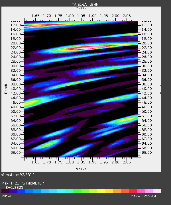
| Estimated Moho Depth: |
21.75 km |
| Estimated Crust Vp/Vs: |
1.88 |
| Assumed Crust Vp: |
6.306 km/s |
| Estimated Crust Vs: |
3.35 km/s |
| Estimated Crust Poisson's Ratio: |
0.30 |
|
| Radial Match: |
92.3312 % |
| Radial Bump: |
400 |
| Transverse Match: |
77.06172 % |
| Transverse Bump: |
400 |
| SOD ConfigId: |
2504 |
| Insert Time: |
2010-03-06 22:00:04.979 +0000 |
| GWidth: |
2.5 |
| Max Bumps: |
400 |
| Tol: |
0.001 |
|
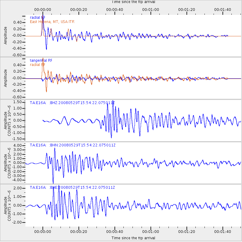
Signal To Noise
| Channel | StoN | STA | LTA |
| TA:E16A: :BHN:20080529T15:54:22.075011Z | 7.1983514 | 9.0361874E-7 | 1.2553134E-7 |
| TA:E16A: :BHE:20080529T15:54:22.075011Z | 3.9438338 | 3.5108835E-7 | 8.90221E-8 |
| TA:E16A: :BHZ:20080529T15:54:22.075011Z | 1.8844966 | 2.55308E-7 | 1.3547809E-7 |
| Arrivals |
| Ps | 3.2 SECOND |
| PpPs | 9.4 SECOND |
| PsPs/PpSs | 13 SECOND |


