You are here: Home > Network List > IU - Global Seismograph Network (GSN - IRIS/USGS) Stations List
> Station SLBS Sierra la Laguna Baja California Sur, Mexico > Earthquake Result Viewer
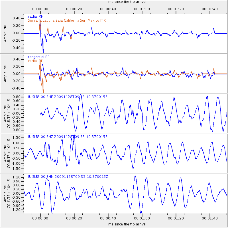
SLBS Sierra la Laguna Baja California Sur, Mexico - Earthquake Result Viewer
*The percent match for this event was below the threshold and hence no stack was calculated.
| Earthquake location: |
Kermadec Islands, New Zealand |
| Earthquake latitude/longitude: |
-29.2/-177.0 |
| Earthquake time(UTC): |
2009/11/28 (332) 09:21:17 GMT |
| Earthquake Depth: |
28 km |
| Earthquake Magnitude: |
5.8 MB, 5.8 MS, 6.0 MW, 5.9 MW |
| Earthquake Catalog/Contributor: |
WHDF/NEIC |
|
| Network: |
IU Global Seismograph Network (GSN - IRIS/USGS) |
| Station: |
SLBS Sierra la Laguna Baja California Sur, Mexico |
| Lat/Lon: |
23.69 N/109.94 W |
| Elevation: |
825 m |
|
| Distance: |
83.2 deg |
| Az: |
58.244 deg |
| Baz: |
234.175 deg |
| Ray Param: |
$rayparam |
*The percent match for this event was below the threshold and hence was not used in the summary stack. |
|
| Radial Match: |
70.66645 % |
| Radial Bump: |
347 |
| Transverse Match: |
45.119797 % |
| Transverse Bump: |
400 |
| SOD ConfigId: |
1 |
| Insert Time: |
2010-02-19 01:17:27.279 +0000 |
| GWidth: |
2.5 |
| Max Bumps: |
400 |
| Tol: |
0.001 |
|
Signal To Noise
| Channel | StoN | STA | LTA |
| IU:SLBS:00:BHZ:20091128T09:33:10.370015Z | 1.1620666 | 4.5611856E-7 | 3.9250642E-7 |
| IU:SLBS:00:BHN:20091128T09:33:10.370015Z | 4.8604965 | 8.3582034E-7 | 1.7196193E-7 |
| IU:SLBS:00:BHE:20091128T09:33:10.370015Z | 0.65989566 | 2.2824345E-7 | 3.458781E-7 |
| Arrivals |
| Ps | |
| PpPs | |
| PsPs/PpSs | |


