You are here: Home > Network List > GS - US Geological Survey Networks Stations List
> Station KAN13 Rinehart Farm > Earthquake Result Viewer
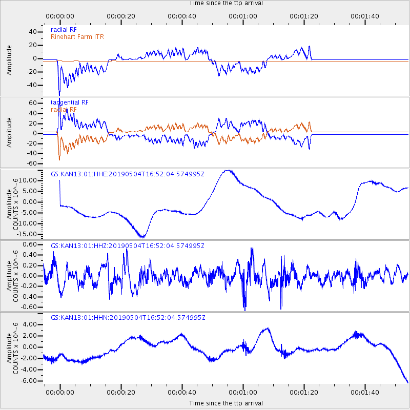
KAN13 Rinehart Farm - Earthquake Result Viewer
*The percent match for this event was below the threshold and hence no stack was calculated.
| Earthquake location: |
Kuril Islands |
| Earthquake latitude/longitude: |
43.2/146.4 |
| Earthquake time(UTC): |
2019/05/04 (124) 16:40:25 GMT |
| Earthquake Depth: |
59 km |
| Earthquake Magnitude: |
5.1 Mww |
| Earthquake Catalog/Contributor: |
NEIC PDE/us |
|
| Network: |
GS US Geological Survey Networks |
| Station: |
KAN13 Rinehart Farm |
| Lat/Lon: |
37.01 N/97.48 W |
| Elevation: |
340 m |
|
| Distance: |
81.3 deg |
| Az: |
46.654 deg |
| Baz: |
318.345 deg |
| Ray Param: |
$rayparam |
*The percent match for this event was below the threshold and hence was not used in the summary stack. |
|
| Radial Match: |
64.79339 % |
| Radial Bump: |
400 |
| Transverse Match: |
61.837845 % |
| Transverse Bump: |
381 |
| SOD ConfigId: |
18252611 |
| Insert Time: |
2019-05-18 16:43:33.292 +0000 |
| GWidth: |
2.5 |
| Max Bumps: |
400 |
| Tol: |
0.001 |
|
Signal To Noise
| Channel | StoN | STA | LTA |
| GS:KAN13:01:HHZ:20190504T16:52:04.574995Z | 1.1825408 | 2.0148885E-7 | 1.7038639E-7 |
| GS:KAN13:01:HHN:20190504T16:52:04.574995Z | 1.3675864 | 3.356209E-6 | 2.4541112E-6 |
| GS:KAN13:01:HHE:20190504T16:52:04.574995Z | 1.0053278 | 2.6404978E-6 | 2.6265043E-6 |
| Arrivals |
| Ps | |
| PpPs | |
| PsPs/PpSs | |


