You are here: Home > Network List > TA - USArray Transportable Network (new EarthScope stations) Stations List
> Station E16A East Helena, MT, USA > Earthquake Result Viewer
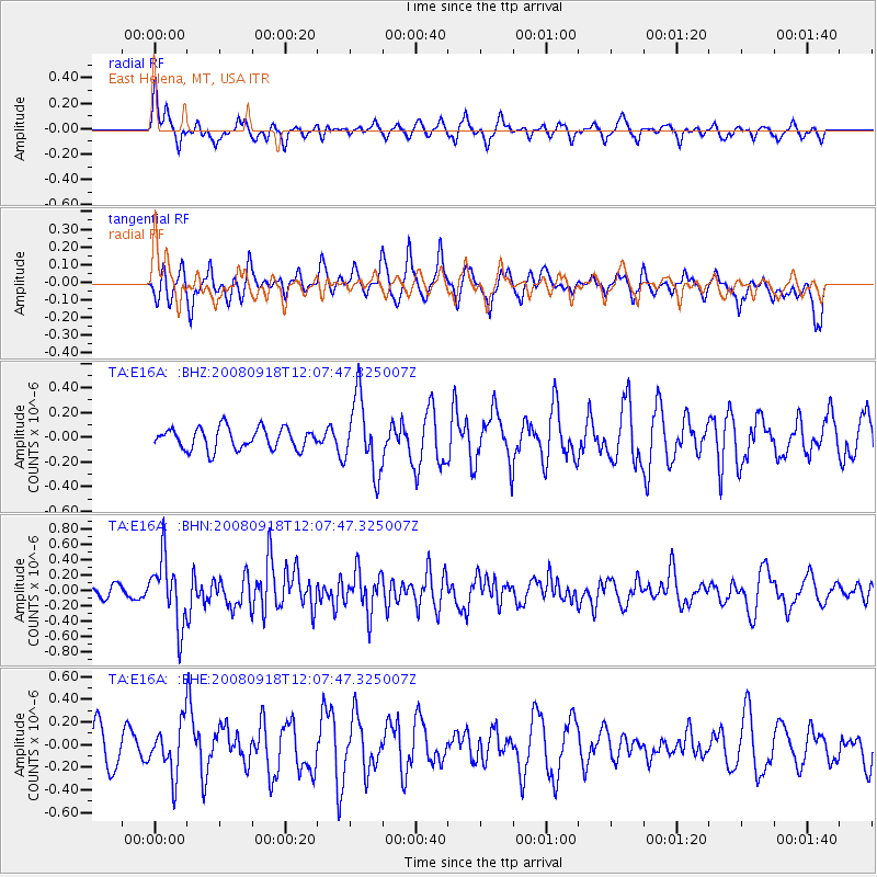
E16A East Helena, MT, USA - Earthquake Result Viewer
*The percent match for this event was below the threshold and hence no stack was calculated.
| Earthquake location: |
Near East Coast Of Kamchatka |
| Earthquake latitude/longitude: |
51.9/158.4 |
| Earthquake time(UTC): |
2008/09/18 (262) 11:58:50 GMT |
| Earthquake Depth: |
67 km |
| Earthquake Magnitude: |
5.7 MB, 5.9 MW, 5.8 MW |
| Earthquake Catalog/Contributor: |
WHDF/NEIC |
|
| Network: |
TA USArray Transportable Network (new EarthScope stations) |
| Station: |
E16A East Helena, MT, USA |
| Lat/Lon: |
46.53 N/111.68 W |
| Elevation: |
1398 m |
|
| Distance: |
55.4 deg |
| Az: |
57.05 deg |
| Baz: |
311.166 deg |
| Ray Param: |
$rayparam |
*The percent match for this event was below the threshold and hence was not used in the summary stack. |
|
| Radial Match: |
43.671314 % |
| Radial Bump: |
341 |
| Transverse Match: |
48.678886 % |
| Transverse Bump: |
347 |
| SOD ConfigId: |
2560 |
| Insert Time: |
2010-03-06 22:01:18.170 +0000 |
| GWidth: |
2.5 |
| Max Bumps: |
400 |
| Tol: |
0.001 |
|
Signal To Noise
| Channel | StoN | STA | LTA |
| TA:E16A: :BHN:20080918T12:07:47.325007Z | 3.555323 | 4.2691804E-7 | 1.2007855E-7 |
| TA:E16A: :BHE:20080918T12:07:47.325007Z | 1.3598286 | 2.2104996E-7 | 1.6255723E-7 |
| TA:E16A: :BHZ:20080918T12:07:47.325007Z | 3.46191 | 2.972664E-7 | 8.586775E-8 |
| Arrivals |
| Ps | |
| PpPs | |
| PsPs/PpSs | |


