You are here: Home > Network List > TA - USArray Transportable Network (new EarthScope stations) Stations List
> Station E16A East Helena, MT, USA > Earthquake Result Viewer
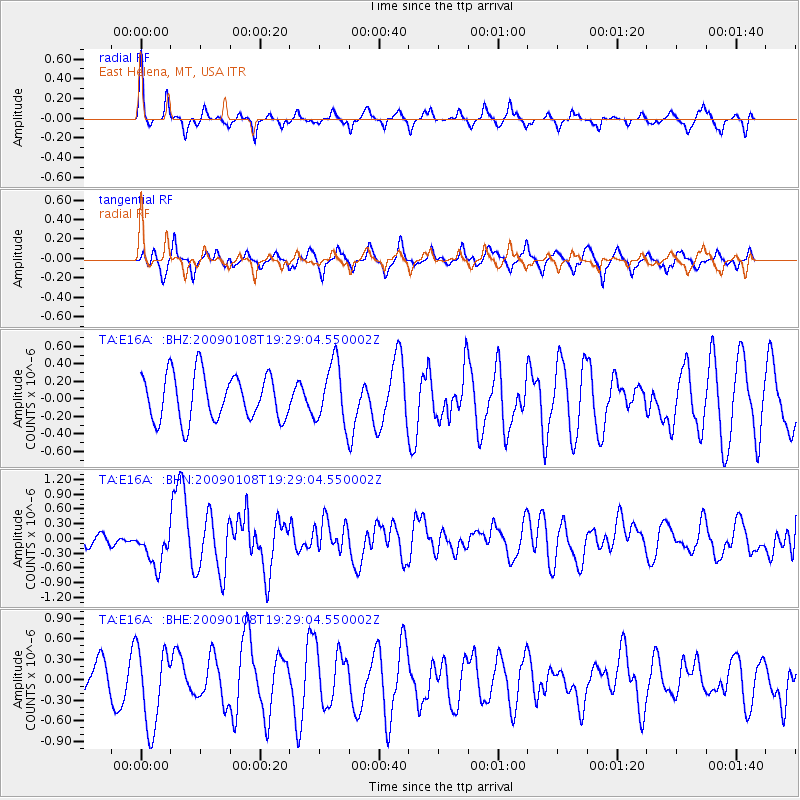
E16A East Helena, MT, USA - Earthquake Result Viewer
*The percent match for this event was below the threshold and hence no stack was calculated.
| Earthquake location: |
Costa Rica |
| Earthquake latitude/longitude: |
10.2/-84.2 |
| Earthquake time(UTC): |
2009/01/08 (008) 19:21:35 GMT |
| Earthquake Depth: |
14 km |
| Earthquake Magnitude: |
5.7 MB, 6.0 MS, 6.1 MW, 6.1 MW |
| Earthquake Catalog/Contributor: |
WHDF/NEIC |
|
| Network: |
TA USArray Transportable Network (new EarthScope stations) |
| Station: |
E16A East Helena, MT, USA |
| Lat/Lon: |
46.53 N/111.68 W |
| Elevation: |
1398 m |
|
| Distance: |
43.1 deg |
| Az: |
332.227 deg |
| Baz: |
138.355 deg |
| Ray Param: |
$rayparam |
*The percent match for this event was below the threshold and hence was not used in the summary stack. |
|
| Radial Match: |
71.52369 % |
| Radial Bump: |
291 |
| Transverse Match: |
62.04557 % |
| Transverse Bump: |
400 |
| SOD ConfigId: |
2834 |
| Insert Time: |
2010-03-06 22:01:20.925 +0000 |
| GWidth: |
2.5 |
| Max Bumps: |
400 |
| Tol: |
0.001 |
|
Signal To Noise
| Channel | StoN | STA | LTA |
| TA:E16A: :BHN:20090108T19:29:04.550002Z | 2.9148822 | 3.8903696E-7 | 1.3346576E-7 |
| TA:E16A: :BHE:20090108T19:29:04.550002Z | 2.0136607 | 5.913119E-7 | 2.9365023E-7 |
| TA:E16A: :BHZ:20090108T19:29:04.550002Z | 1.319485 | 3.441568E-7 | 2.6082662E-7 |
| Arrivals |
| Ps | |
| PpPs | |
| PsPs/PpSs | |


