You are here: Home > Network List > TA - USArray Transportable Network (new EarthScope stations) Stations List
> Station E16A East Helena, MT, USA > Earthquake Result Viewer
E16A East Helena, MT, USA - Earthquake Result Viewer
*The percent match for this event was below the threshold and hence no stack was calculated.
| Earthquake location: |
South Of Fiji Islands |
| Earthquake latitude/longitude: |
-22.2/-179.7 |
| Earthquake time(UTC): |
2008/11/19 (324) 20:38:58 GMT |
| Earthquake Depth: |
596 km |
| Earthquake Magnitude: |
5.8 MW, 5.2 MB, 5.8 MW |
| Earthquake Catalog/Contributor: |
WHDF/NEIC |
|
| Network: |
TA USArray Transportable Network (new EarthScope stations) |
| Station: |
E16A East Helena, MT, USA |
| Lat/Lon: |
46.53 N/111.68 W |
| Elevation: |
1398 m |
|
| Distance: |
91.8 deg |
| Az: |
39.837 deg |
| Baz: |
239.334 deg |
| Ray Param: |
$rayparam |
*The percent match for this event was below the threshold and hence was not used in the summary stack. |
|
| Radial Match: |
77.62021 % |
| Radial Bump: |
400 |
| Transverse Match: |
62.045444 % |
| Transverse Bump: |
368 |
| SOD ConfigId: |
2658 |
| Insert Time: |
2010-03-06 22:01:24.268 +0000 |
| GWidth: |
2.5 |
| Max Bumps: |
400 |
| Tol: |
0.001 |
|
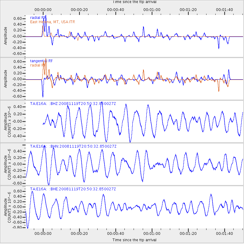
Signal To Noise
| Channel | StoN | STA | LTA |
| TA:E16A: :BHN:20081119T20:50:32.850027Z | 1.5118731 | 4.127293E-7 | 2.7299203E-7 |
| TA:E16A: :BHE:20081119T20:50:32.850027Z | 1.092602 | 3.140355E-7 | 2.8741985E-7 |
| TA:E16A: :BHZ:20081119T20:50:32.850027Z | 1.4819168 | 3.3835673E-7 | 2.283237E-7 |
| Arrivals |
| Ps | |
| PpPs | |
| PsPs/PpSs | |


