You are here: Home > Network List > TS - TERRAscope (Southern California Seismic Network) Stations List
> Station DGR Domenigoni Valley Reservior, California, USA > Earthquake Result Viewer
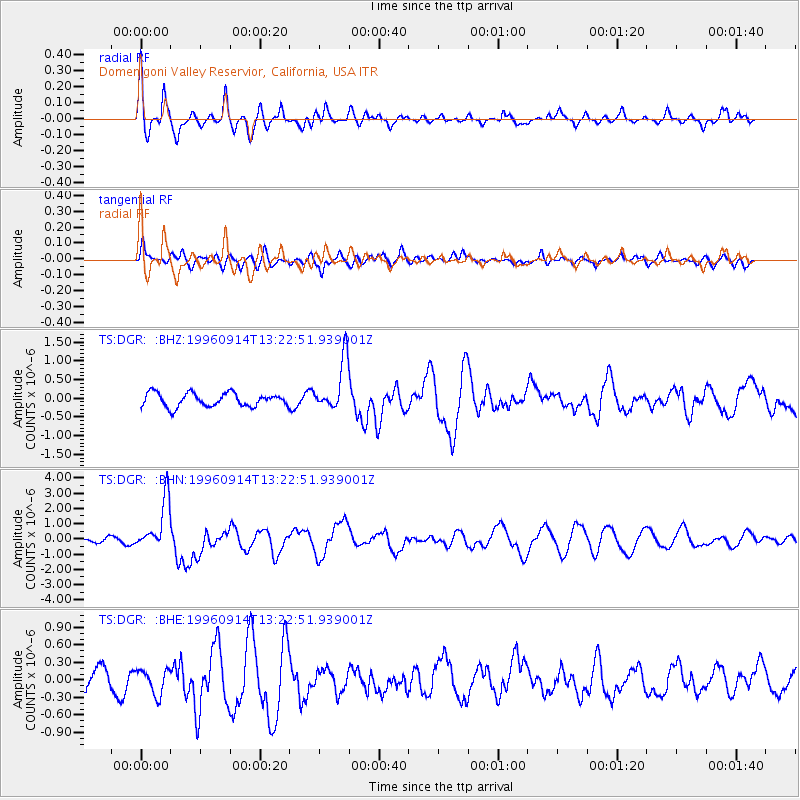
DGR Domenigoni Valley Reservior, California, USA - Earthquake Result Viewer
*The percent match for this event was below the threshold and hence no stack was calculated.
| Earthquake location: |
Santa Cruz Islands |
| Earthquake latitude/longitude: |
-10.9/166.0 |
| Earthquake time(UTC): |
1996/09/14 (258) 13:10:53 GMT |
| Earthquake Depth: |
73 km |
| Earthquake Magnitude: |
6.0 MB, 6.0 MS, 6.4 UNKNOWN, 6.4 MW |
| Earthquake Catalog/Contributor: |
WHDF/NEIC |
|
| Network: |
TS TERRAscope (Southern California Seismic Network) |
| Station: |
DGR Domenigoni Valley Reservior, California, USA |
| Lat/Lon: |
33.65 N/117.01 W |
| Elevation: |
700 m |
|
| Distance: |
85.4 deg |
| Az: |
54.631 deg |
| Baz: |
253.788 deg |
| Ray Param: |
$rayparam |
*The percent match for this event was below the threshold and hence was not used in the summary stack. |
|
| Radial Match: |
62.81339 % |
| Radial Bump: |
400 |
| Transverse Match: |
49.244823 % |
| Transverse Bump: |
400 |
| SOD ConfigId: |
4480 |
| Insert Time: |
2010-02-26 14:11:36.911 +0000 |
| GWidth: |
2.5 |
| Max Bumps: |
400 |
| Tol: |
0.001 |
|
Signal To Noise
| Channel | StoN | STA | LTA |
| TS:DGR: :BHN:19960914T13:22:51.939001Z | 10.195911 | 1.6576962E-6 | 1.6258441E-7 |
| TS:DGR: :BHE:19960914T13:22:51.939001Z | 1.3844042 | 2.1816159E-7 | 1.5758518E-7 |
| TS:DGR: :BHZ:19960914T13:22:51.939001Z | 3.8208137 | 6.9157954E-7 | 1.810032E-7 |
| Arrivals |
| Ps | |
| PpPs | |
| PsPs/PpSs | |


