You are here: Home > Network List > TA - USArray Transportable Network (new EarthScope stations) Stations List
> Station E16A East Helena, MT, USA > Earthquake Result Viewer
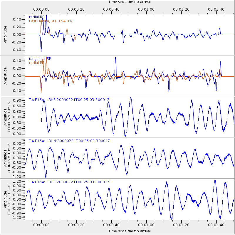
E16A East Helena, MT, USA - Earthquake Result Viewer
*The percent match for this event was below the threshold and hence no stack was calculated.
| Earthquake location: |
Ryukyu Islands, Japan |
| Earthquake latitude/longitude: |
28.9/130.9 |
| Earthquake time(UTC): |
2009/02/21 (052) 00:12:56 GMT |
| Earthquake Depth: |
24 km |
| Earthquake Magnitude: |
5.6 MB, 5.0 MS, 5.5 MW, 5.5 MW |
| Earthquake Catalog/Contributor: |
WHDF/NEIC |
|
| Network: |
TA USArray Transportable Network (new EarthScope stations) |
| Station: |
E16A East Helena, MT, USA |
| Lat/Lon: |
46.53 N/111.68 W |
| Elevation: |
1398 m |
|
| Distance: |
86.1 deg |
| Az: |
37.881 deg |
| Baz: |
308.734 deg |
| Ray Param: |
$rayparam |
*The percent match for this event was below the threshold and hence was not used in the summary stack. |
|
| Radial Match: |
71.14906 % |
| Radial Bump: |
400 |
| Transverse Match: |
53.152946 % |
| Transverse Bump: |
351 |
| SOD ConfigId: |
2658 |
| Insert Time: |
2010-03-06 22:01:27.943 +0000 |
| GWidth: |
2.5 |
| Max Bumps: |
400 |
| Tol: |
0.001 |
|
Signal To Noise
| Channel | StoN | STA | LTA |
| TA:E16A: :BHN:20090221T00:25:03.30001Z | 2.418227 | 5.973962E-7 | 2.470389E-7 |
| TA:E16A: :BHE:20090221T00:25:03.30001Z | 1.1365073 | 3.6327546E-7 | 3.19642E-7 |
| TA:E16A: :BHZ:20090221T00:25:03.30001Z | 0.47082877 | 1.5054155E-7 | 3.1973738E-7 |
| Arrivals |
| Ps | |
| PpPs | |
| PsPs/PpSs | |


