You are here: Home > Network List > PF - Volcanologic Network of Piton de Fournaise-OVPF Stations List
> Station GPS Grandes Pentes Sud > Earthquake Result Viewer
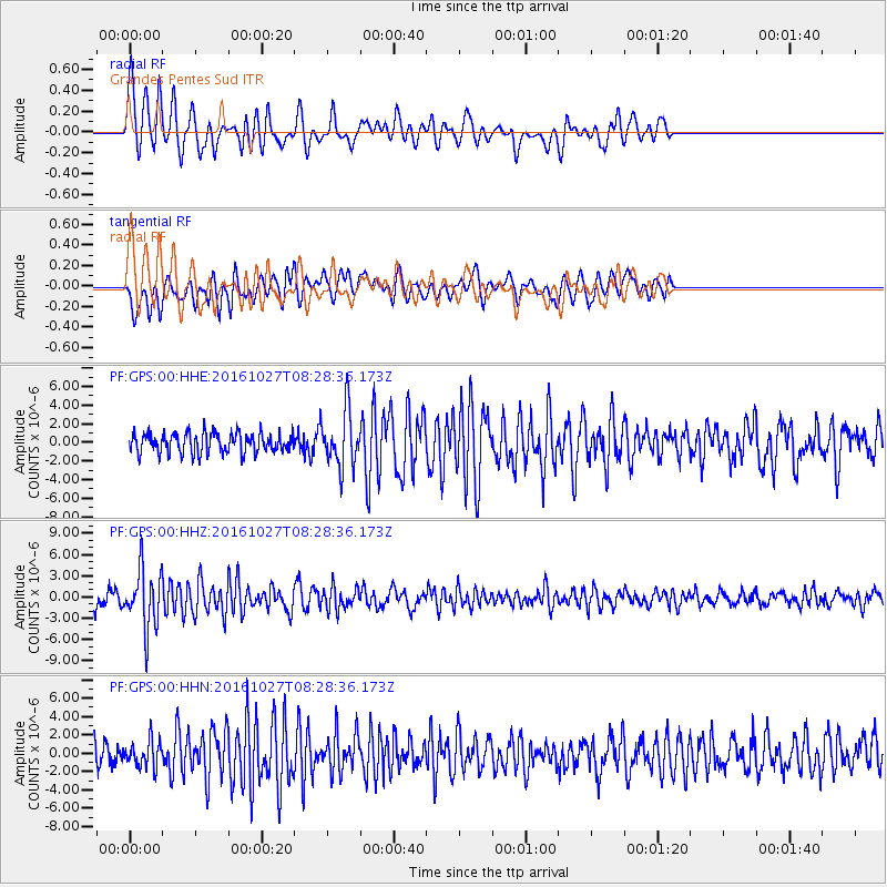
GPS Grandes Pentes Sud - Earthquake Result Viewer
*The percent match for this event was below the threshold and hence no stack was calculated.
| Earthquake location: |
Northern Molucca Sea |
| Earthquake latitude/longitude: |
1.3/125.8 |
| Earthquake time(UTC): |
2016/10/27 (301) 08:17:49 GMT |
| Earthquake Depth: |
56 km |
| Earthquake Magnitude: |
5.9 MB, 5.8 MWB |
| Earthquake Catalog/Contributor: |
NEIC PDE/NEIC COMCAT |
|
| Network: |
PF Volcanologic Network of Piton de Fournaise-OVPF |
| Station: |
GPS Grandes Pentes Sud |
| Lat/Lon: |
21.27 S/55.76 E |
| Elevation: |
1004 m |
|
| Distance: |
71.9 deg |
| Az: |
247.236 deg |
| Baz: |
81.251 deg |
| Ray Param: |
$rayparam |
*The percent match for this event was below the threshold and hence was not used in the summary stack. |
|
| Radial Match: |
71.58343 % |
| Radial Bump: |
383 |
| Transverse Match: |
62.096664 % |
| Transverse Bump: |
400 |
| SOD ConfigId: |
1815711 |
| Insert Time: |
2016-11-10 08:21:59.205 +0000 |
| GWidth: |
2.5 |
| Max Bumps: |
400 |
| Tol: |
0.001 |
|
Signal To Noise
| Channel | StoN | STA | LTA |
| PF:GPS:00:HHZ:20161027T08:28:36.173Z | 5.1331954 | 4.0644754E-6 | 7.9180217E-7 |
| PF:GPS:00:HHN:20161027T08:28:36.173Z | 1.2028555 | 1.4460344E-6 | 1.202168E-6 |
| PF:GPS:00:HHE:20161027T08:28:36.173Z | 2.7830937 | 3.0170027E-6 | 1.0840464E-6 |
| Arrivals |
| Ps | |
| PpPs | |
| PsPs/PpSs | |


