You are here: Home > Network List > TA - USArray Transportable Network (new EarthScope stations) Stations List
> Station E16A East Helena, MT, USA > Earthquake Result Viewer
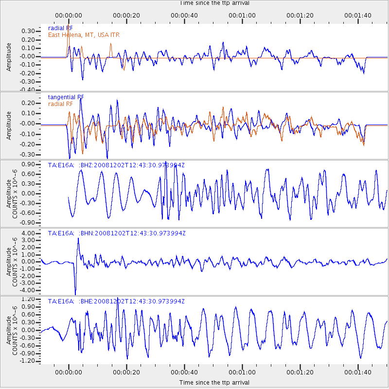
E16A East Helena, MT, USA - Earthquake Result Viewer
*The percent match for this event was below the threshold and hence no stack was calculated.
| Earthquake location: |
Mariana Islands |
| Earthquake latitude/longitude: |
19.1/145.8 |
| Earthquake time(UTC): |
2008/12/02 (337) 12:31:43 GMT |
| Earthquake Depth: |
137 km |
| Earthquake Magnitude: |
5.9 MB, 5.9 MW, 5.9 MW |
| Earthquake Catalog/Contributor: |
WHDF/NEIC |
|
| Network: |
TA USArray Transportable Network (new EarthScope stations) |
| Station: |
E16A East Helena, MT, USA |
| Lat/Lon: |
46.53 N/111.68 W |
| Elevation: |
1398 m |
|
| Distance: |
84.6 deg |
| Az: |
42.591 deg |
| Baz: |
292.036 deg |
| Ray Param: |
$rayparam |
*The percent match for this event was below the threshold and hence was not used in the summary stack. |
|
| Radial Match: |
47.21037 % |
| Radial Bump: |
361 |
| Transverse Match: |
64.11965 % |
| Transverse Bump: |
381 |
| SOD ConfigId: |
2658 |
| Insert Time: |
2010-03-06 22:01:32.127 +0000 |
| GWidth: |
2.5 |
| Max Bumps: |
400 |
| Tol: |
0.001 |
|
Signal To Noise
| Channel | StoN | STA | LTA |
| TA:E16A: :BHN:20081202T12:43:30.973994Z | 5.458935 | 1.6280447E-6 | 2.982349E-7 |
| TA:E16A: :BHE:20081202T12:43:30.973994Z | 2.7893255 | 4.1450596E-7 | 1.4860437E-7 |
| TA:E16A: :BHZ:20081202T12:43:30.973994Z | 1.1787916 | 4.901576E-7 | 4.158136E-7 |
| Arrivals |
| Ps | |
| PpPs | |
| PsPs/PpSs | |


