You are here: Home > Network List > TA - USArray Transportable Network (new EarthScope stations) Stations List
> Station D23K Nanushuk River, AK USA > Earthquake Result Viewer
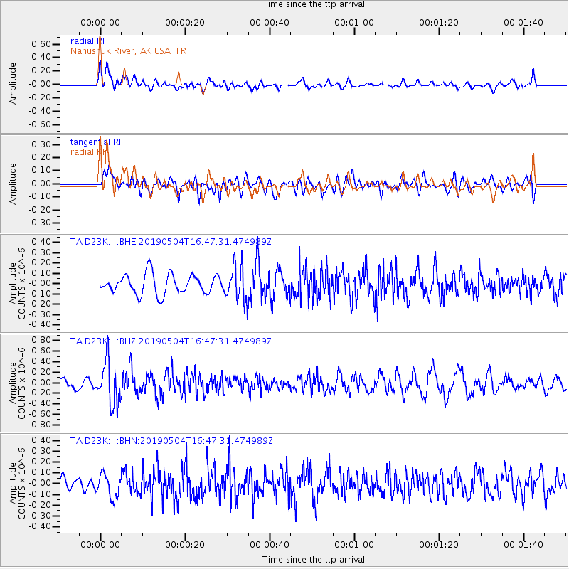
D23K Nanushuk River, AK USA - Earthquake Result Viewer
*The percent match for this event was below the threshold and hence no stack was calculated.
| Earthquake location: |
Kuril Islands |
| Earthquake latitude/longitude: |
43.2/146.4 |
| Earthquake time(UTC): |
2019/05/04 (124) 16:40:25 GMT |
| Earthquake Depth: |
59 km |
| Earthquake Magnitude: |
5.1 Mww |
| Earthquake Catalog/Contributor: |
NEIC PDE/us |
|
| Network: |
TA USArray Transportable Network (new EarthScope stations) |
| Station: |
D23K Nanushuk River, AK USA |
| Lat/Lon: |
68.97 N/150.68 W |
| Elevation: |
406 m |
|
| Distance: |
40.9 deg |
| Az: |
29.412 deg |
| Baz: |
264.32 deg |
| Ray Param: |
$rayparam |
*The percent match for this event was below the threshold and hence was not used in the summary stack. |
|
| Radial Match: |
58.21762 % |
| Radial Bump: |
400 |
| Transverse Match: |
59.919132 % |
| Transverse Bump: |
400 |
| SOD ConfigId: |
18252611 |
| Insert Time: |
2019-05-18 16:46:32.626 +0000 |
| GWidth: |
2.5 |
| Max Bumps: |
400 |
| Tol: |
0.001 |
|
Signal To Noise
| Channel | StoN | STA | LTA |
| TA:D23K: :BHZ:20190504T16:47:31.474989Z | 3.0447552 | 4.0421727E-7 | 1.3275854E-7 |
| TA:D23K: :BHN:20190504T16:47:31.474989Z | 1.506834 | 1.084563E-7 | 7.1976274E-8 |
| TA:D23K: :BHE:20190504T16:47:31.474989Z | 1.7045546 | 1.6599243E-7 | 9.738171E-8 |
| Arrivals |
| Ps | |
| PpPs | |
| PsPs/PpSs | |


