You are here: Home > Network List > TA - USArray Transportable Network (new EarthScope stations) Stations List
> Station D25K Kavik River, AK, USA > Earthquake Result Viewer
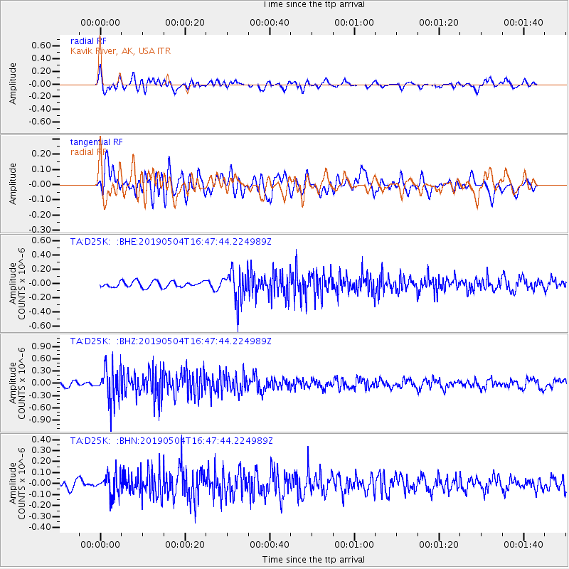
D25K Kavik River, AK, USA - Earthquake Result Viewer
*The percent match for this event was below the threshold and hence no stack was calculated.
| Earthquake location: |
Kuril Islands |
| Earthquake latitude/longitude: |
43.2/146.4 |
| Earthquake time(UTC): |
2019/05/04 (124) 16:40:25 GMT |
| Earthquake Depth: |
59 km |
| Earthquake Magnitude: |
5.1 Mww |
| Earthquake Catalog/Contributor: |
NEIC PDE/us |
|
| Network: |
TA USArray Transportable Network (new EarthScope stations) |
| Station: |
D25K Kavik River, AK, USA |
| Lat/Lon: |
69.32 N/146.38 W |
| Elevation: |
770 m |
|
| Distance: |
42.4 deg |
| Az: |
29.029 deg |
| Baz: |
268.054 deg |
| Ray Param: |
$rayparam |
*The percent match for this event was below the threshold and hence was not used in the summary stack. |
|
| Radial Match: |
53.99123 % |
| Radial Bump: |
400 |
| Transverse Match: |
68.71633 % |
| Transverse Bump: |
400 |
| SOD ConfigId: |
18252611 |
| Insert Time: |
2019-05-18 16:46:33.844 +0000 |
| GWidth: |
2.5 |
| Max Bumps: |
400 |
| Tol: |
0.001 |
|
Signal To Noise
| Channel | StoN | STA | LTA |
| TA:D25K: :BHZ:20190504T16:47:44.224989Z | 5.7881703 | 4.092539E-7 | 7.070522E-8 |
| TA:D25K: :BHN:20190504T16:47:44.224989Z | 2.1002107 | 9.556383E-8 | 4.550202E-8 |
| TA:D25K: :BHE:20190504T16:47:44.224989Z | 5.417158 | 2.2249952E-7 | 4.1073108E-8 |
| Arrivals |
| Ps | |
| PpPs | |
| PsPs/PpSs | |


